

Volcano Peak is a 6,011-foot elevation (1,832 m) mountain summit located in Tooele County, Utah, United States.
Description
Volcano Peak is situated in the Silver Island Mountains which are a subset of the Great Basin Ranges, and it is set on land managed by the Bureau of Land Management. The community of Wendover, Utah, is six miles to the southwest and line parent Rishel Peak is two miles to the northeast. Topographic relief is modest as the summit rises 1,800 feet (550 meters) above the Bonneville Salt Flats in 1.5 mile. This landform's toponym has been officially adopted by the U.S. Board on Geographic Names.[4]
Climate
Volcano Peak is set in the Great Salt Lake Desert which has hot summers and cold winters.[6] The desert is an example of a cold desert climate as the desert's elevation makes temperatures cooler than lower elevation deserts. Due to the high elevation and aridity, temperatures drop sharply after sunset. Summer nights are comfortably cool. Winter highs are generally above freezing, and winter nights are bitterly cold, with temperatures often dropping well below freezing.
Gallery
-

-
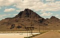
 Volcano Peak (left), Rishel Peak (left of center) and Tetzlaff Peak (right) from Bonneville Salt Flats
 -

-
 Southwest slope
 -
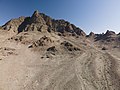
 South aspect
 -


See also
References
- ^ United States Geological Survey topographical map - Tetzlaff Peak
- ^ "Volcano Peak, Utah". Peakbagger.com. Retrieved 2022-08-23.
- ^ a b c "Volcano Peak - 6,011' UT". listsofjohn.com. Retrieved 2022-08-23.
- ^ a b "Volcano Peak". Geographic Names Information System. United States Geological Survey, United States Department of the Interior. Retrieved 2022-08-23.
- ^ Utah Geological Society (1960), Guidebook to the Geology of Utah, p. 173
- ^ Peel, M. C.; Finlayson, B. L.; McMahon, T. A. (2007). "Updated world map of the Köppen−Geiger climate classification". Hydrol. Earth Syst. Sci. 11. ISSN 1027-5606.
External links
- Volcano Peak: weather forecast