

Size of this preview: 800 × 565 pixels. Other resolutions: 320 × 226 pixels | 640 × 452 pixels | 938 × 662 pixels.
Original file (938 × 662 pixels, file size: 12 KB, MIME type: image/png)

|
This map image could be re-created using vector graphics as an SVG file. This has several advantages; see Commons:Media for cleanup for more information. If an SVG form of this image is available, please upload it and afterwards replace this template with
{{vector version available|new image name}}.
It is recommended to name the SVG file “Beidou-coverage.svg”—then the template Vector version available (or Vva) does not need the new image name parameter. |
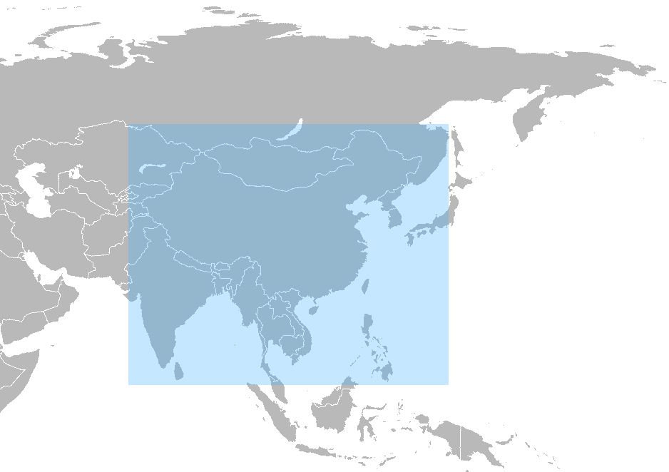
| Description | Coverage of Chinese local positioning system en:Beidou navigation system. |
| Date | (UTC) |
| Source | |
| Author |
|
| Other versions | Derivative works of this file: Beidou-system-coverage.png |
| This is a retouched picture, which means that it has been digitally altered from its original version. Modifications: Japan and Korea grayed, coverage of Beidou added. The original can be viewed here: China-Japan-South Korea trilateral meeting.png:
|
I, the copyright holder of this work, hereby publish it under the following license:
| I, the copyright holder of this work, release this work into the public domain. This applies worldwide. In some countries this may not be legally possible; if so: I grant anyone the right to use this work for any purpose, without any conditions, unless such conditions are required by law. |
Original upload log
This image is a derivative work of the following images:
- File:China-Japan-South_Korea__trilateral_meeting.png licensed with PD-self
- 2008-12-24T04:19:13Z Myouzke 938x681 (21301 Bytes) {{Information |Description= |Source= |Date= |Author= |Permission= |other_versions= }}
- 2008-12-22T19:06:05Z Myouzke 1425x625 (33495 Bytes) {{Information |Description= |Source= |Date= |Author= |Permission= |other_versions= }}
- 2008-12-20T18:54:57Z Myouzke 1425x625 (33476 Bytes) == Summary == {{Information |Description=Map of the world with China-Japan-South Korea participating in trilateral meeting are highlighted in green . |Source=Adapted from [[:File:BlankMap-World6.svg]] |Author=[[Us
Uploaded with derivativeFX
File history
Click on a date/time to view the file as it appeared at that time.
| Date/Time | Thumbnail | Dimensions | User | Comment | |
|---|---|---|---|---|---|
| current | 15:14, 26 April 2012 | | 938 × 662 (12 KB) | Lux.r.ck | reset all things. |
| 15:13, 26 April 2012 |  | 938 × 662 (12 KB) | Lux.r.ck | reset all things. | |
| 07:26, 24 April 2012 |  | 938 × 662 (12 KB) | Lux.r.ck | change taiwan to pink | |
| 07:26, 24 April 2012 |  | 938 × 662 (12 KB) | Lux.r.ck | change taiwan to pink | |
| 21:35, 24 March 2010 |  | 938 × 662 (12 KB) | Kriplozoik | {{Information |Description=Coverage of Chinese local positioning system en:Beidou. |Source=*File:China-Japan-South_Korea__trilateral_meeting.png |Date=2010-03-24 21:33 (UTC) |Author=*File:China-Japan-South_Korea__trilateral_meeting.png: [ |
File usage
The following pages on the English Wikipedia use this file (pages on other projects are not listed):
Global file usage
The following other wikis use this file:
- Usage on ar.wikipedia.org
- Usage on ca.wikipedia.org
- Usage on cs.wikipedia.org
- Usage on de.wikipedia.org
- Usage on fi.wikipedia.org
- Usage on fr.wikipedia.org
- Usage on id.wikipedia.org
- Usage on it.wikipedia.org
- Usage on ko.wikipedia.org
- Usage on nl.wikipedia.org
- Usage on no.wikipedia.org
- Usage on pl.wikipedia.org
- Usage on ru.wikipedia.org
- Usage on uk.wikipedia.org
- Usage on uz.wikipedia.org
- Usage on vi.wikipedia.org
- Usage on zh.wikipedia.org