


Size of this preview: 800 × 446 pixels. Other resolutions: 320 × 178 pixels | 640 × 357 pixels | 1,024 × 571 pixels | 1,280 × 714 pixels | 2,560 × 1,427 pixels | 3,944 × 2,199 pixels.
Original file (3,944 × 2,199 pixels, file size: 4.48 MB, MIME type: image/jpeg)
Summary
| Description |
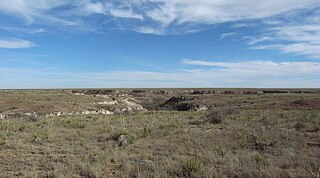
English: A canyon carved into the high plains by Tierra Blanca Creek, home of Buffalo Lake National Wildlife Refuge. |
| Date | |
| Source | Own work |
| Author | Leaflet |
| Other versions | Public domain photos of the Rolling Plains of West Texas |
| Camera location | | View this and other nearby images on: OpenStreetMap |
|---|
Licensing
I, the copyright holder of this work, hereby publish it under the following license:
This file is licensed under the Creative Commons Attribution-Share Alike 3.0 Unported license.
- You are free:
- to share – to copy, distribute and transmit the work
- to remix – to adapt the work
- Under the following conditions:
- attribution – You must give appropriate credit, provide a link to the license, and indicate if changes were made. You may do so in any reasonable manner, but not in any way that suggests the licensor endorses you or your use.
- share alike – If you remix, transform, or build upon the material, you must distribute your contributions under the same or compatible license as the original.
File history
Click on a date/time to view the file as it appeared at that time.
| Date/Time | Thumbnail | Dimensions | User | Comment | |
|---|---|---|---|---|---|
| current | 03:52, 28 November 2009 | | 3,944 × 2,199 (4.48 MB) | Leaflet | {{Information |Description={{en|1=A canyon formed by {{w|Tierra Blanca Creek}}, home of {{w|Buffalo Lake National Wildlife Refuge}}}} |Source={{own}} |Author=Leaflet |Date=2009-11-27 |Permission= |other_versions= }} [[Category:Randall Co |
File usage
The following pages on the English Wikipedia use this file (pages on other projects are not listed):
Global file usage
The following other wikis use this file:
- Usage on ceb.wikipedia.org
- Usage on sv.wikipedia.org
- Usage on www.wikidata.org