

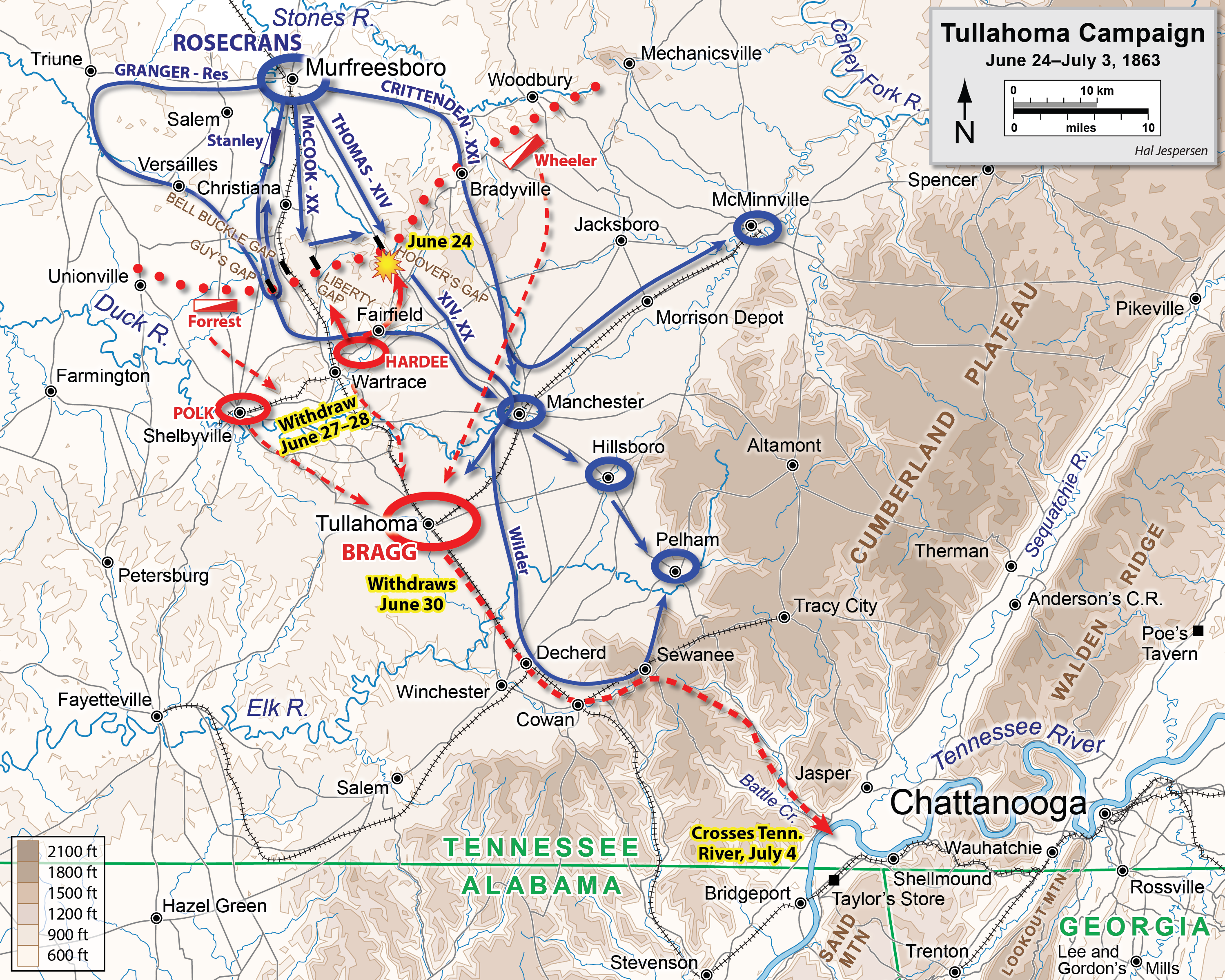
Size of this preview: 750 × 600 pixels. Other resolutions: 300 × 240 pixels | 600 × 480 pixels | 960 × 768 pixels | 1,280 × 1,024 pixels | 2,560 × 2,048 pixels | 3,000 × 2,400 pixels.
Original file (3,000 × 2,400 pixels, file size: 3.93 MB, MIME type: image/png)
Summary
| Description | |
| Date | |
| Source | Own work, derived from source http://www.posix.com/CWmaps/ (PD) |
| Author | Hal Jespersen |
Licensing
Hal Jespersen at en.wikipedia, the copyright holder of this work, hereby publishes it under the following license:
This file is licensed under the Creative Commons Attribution 3.0 Unported license.
Attribution: Map by Hal Jespersen, www.posix.com/CW
- You are free:
- to share – to copy, distribute and transmit the work
- to remix – to adapt the work
- Under the following conditions:
- attribution – You must give appropriate credit, provide a link to the license, and indicate if changes were made. You may do so in any reasonable manner, but not in any way that suggests the licensor endorses you or your use.
Original upload log
The original description page was here. All following user names refer to en.wikipedia.
- 2009-03-03 17:14 Hlj 2979×1977× (887222 bytes) Corrected placement of railroad through Sewanee. Same license. {{cc-by-3.0|Map by Hal Jespersen, www.posix.com/CW}}
- 2008-07-14 01:57 Hlj 3000×1991× (1571509 bytes) Smaller # of pixels. {{cc-by-3.0|Map by Hal Jespersen, www.posix.com/CW}}
- 2008-07-14 01:52 Hlj 6207×4119× (1326496 bytes) Map of the [[Tullahoma Campaign]] of the [[American Civil War]]. Drawn by Hal Jespersen in Adobe Illustrator. Graphic source file is available at http://www.posix.com/CWmaps/ {{cc-by-3.0|Map by Hal Jespersen, www.posix.com/CW}}
File history
Click on a date/time to view the file as it appeared at that time.
| Date/Time | Thumbnail | Dimensions | User | Comment | |
|---|---|---|---|---|---|
| current | 19:28, 27 December 2022 | | 3,000 × 2,400 (3.93 MB) | Hlj | improved graphics |
| 23:33, 30 March 2011 |  | 2,411 × 1,617 (837 KB) | Hlj | Updated graphical format of rivers and roads. Same license. | |
| 15:24, 24 January 2010 |  | 2,979 × 1,977 (866 KB) | BotMultichill | {{BotMoveToCommons|en.wikipedia|year={{subst:CURRENTYEAR}}|month={{subst:CURRENTMONTHNAME}}|day={{subst:CURRENTDAY}}}} {{Information |Description={{en|Map of the en:Tullahoma Campaign of the en:American Civil War. Drawn by Hal Jespersen in A |
File usage
The following pages on the English Wikipedia use this file (pages on other projects are not listed):
Global file usage
The following other wikis use this file:
- Usage on ar.wikipedia.org
- Usage on de.wikipedia.org
- Usage on en.wikivoyage.org
- Usage on fr.wikipedia.org
- Usage on he.wikipedia.org
- Usage on hu.wikipedia.org
- Usage on it.wikipedia.org
- Usage on nl.wikipedia.org
- Usage on pt.wikipedia.org
- Usage on sv.wikipedia.org
- Usage on uk.wikipedia.org
- Usage on www.wikidata.org