

The Andes Portal

The Andes (/ˈændiːz/ AN-deez), Andes Mountains or Andean Mountain Range (Spanish: Cordillera de los Andes; Quechua: Anti) are the longest continental mountain range in the world, forming a continuous highland along the western edge of South America. The range is 8,900 km (5,530 mi) long and 200 to 700 km (124 to 435 mi) wide (widest between 18°S and 20°S latitude) and has an average height of about 4,000 m (13,123 ft). The Andes extend from north to south through seven South American countries: Venezuela, Colombia, Ecuador, Peru, Bolivia, Chile and Argentina.
Along their length, the Andes are split into several ranges, separated by intermediate depressions. The Andes are the location of several high plateaus—some of which host major cities such as Quito, Bogotá, Cali, Arequipa, Medellín, Bucaramanga, Sucre, Mérida, El Alto and La Paz. The Altiplano Plateau is the world's second-highest after the Tibetan Plateau. These ranges are in turn grouped into three major divisions based on climate: the Tropical Andes, the Dry Andes, and the Wet Andes.
The Andes Mountains are the highest mountain range outside Asia. The highest mountain outside Asia, Argentina's Aconcagua, rises to an elevation of about 6,961 m (22,838 ft) above sea level. The peak of Chimborazo in the Ecuadorian Andes is farther from the Earth's center than any other location on the Earth's surface, due to the equatorial bulge resulting from the Earth's rotation. The world's highest volcanoes are in the Andes, including Ojos del Salado on the Chile-Argentina border, which rises to 6,893 m (22,615 ft). (Full article...)
Selected articles
-
![Image 1 Steam on the mountain in July 2007 Nevado del Ruiz (Spanish pronunciation: [neβaðo ðel ˈrwis]), also known as La Mesa de Herveo (English: Mesa of Herveo, the name of the nearby town) is a volcano on the border of the departments of Caldas and Tolima in Colombia, about 129 km (80 mi) west of the capital city Bogotá. It is a stratovolcano composed of many layers of lava alternating with hardened volcanic ash and other pyroclastic rocks. Volcanic activity at Nevado del Ruiz began about two million years ago, during the Early Pleistocene or Late Pliocene, with three major eruptive periods. The current volcanic cone formed during the present eruptive period, which began 150,000 years ago. The volcano usually generates Vulcanian to Plinian eruptions, which produce swift-moving currents of hot gas and rock called pyroclastic flows. These eruptions often cause massive lahars (mud and debris flows), which pose a threat to human life and the environment. The impact of such an eruption is increased as the hot gas and lava melt the mountain's snowcap, adding large quantities of water to the flow. On November 13, 1985, a small eruption produced an enormous lahar that buried and destroyed the town of Armero in Tolima, causing an estimated 25,000 deaths. This event later became known as the Armero tragedy—the deadliest lahar in recorded history. Similar but less deadly incidents occurred in 1595 and 1845, consisting of a small explosive eruption followed by a large lahar. (Full article...)](https://upload.wikimedia.org/wikipedia/en/d/d2/Blank.png)
Nevado del Ruiz (Spanish pronunciation: [neβaðo ðel ˈrwis]), also known as La Mesa de Herveo (English: Mesa of Herveo, the name of the nearby town) is a volcano on the border of the departments of Caldas and Tolima in Colombia, about 129 km (80 mi) west of the capital city Bogotá. It is a stratovolcano composed of many layers of lava alternating with hardened volcanic ash and other pyroclastic rocks. Volcanic activity at Nevado del Ruiz began about two million years ago, during the Early Pleistocene or Late Pliocene, with three major eruptive periods. The current volcanic cone formed during the present eruptive period, which began 150,000 years ago.
The volcano usually generates Vulcanian to Plinian eruptions, which produce swift-moving currents of hot gas and rock called pyroclastic flows. These eruptions often cause massive lahars (mud and debris flows), which pose a threat to human life and the environment. The impact of such an eruption is increased as the hot gas and lava melt the mountain's snowcap, adding large quantities of water to the flow. On November 13, 1985, a small eruption produced an enormous lahar that buried and destroyed the town of Armero in Tolima, causing an estimated 25,000 deaths. This event later became known as the Armero tragedy—the deadliest lahar in recorded history. Similar but less deadly incidents occurred in 1595 and 1845, consisting of a small explosive eruption followed by a large lahar. (Full article...) -
Pumasillo (possibly from Quechua puma cougar, puma, sillu claw, "puma claw") is a mountain in the Vilcabamba mountain range in the Andes of Peru, about 5,991 m (19,656 ft) high'. Pumasillo or Sacsarayoc also refers to the whole massif. It includes the peaks Pumasillo, Sacsarayoc and Lasunayoc. It is located in the Cusco Region, La Convención Province. Its slopes are within the administrative boundaries of the Peruvian city of Santa Teresa. ('Full article...) -
Los Nevados National Natural Park (Spanish: Parque Nacional Natural Los Nevados) is a national park located in the Cordillera Central of the Colombian Andes. The park surrounds the northern volcanic complex formed by Nevado del Ruiz, Nevado del Tolima, Nevado de Santa Isabel, the paramillos of Cisne, Santa Rosa and Quindío and the Cerro Bravo and Cerro Machín.
The park is located in the departments of Caldas, Quindío, Risaralda, Tolima and spans between the municipalities Manizales, Villamaría, Santa Rosa de Cabal, Pereira, Salento, Villahermosa, Anzoátegui, Santa Isabel, Murillo, Ibagué and Casabianca. (Full article...) -

A map of the endorheic river basins that characterize the altiplano. In the north is Lake Titicaca and the Desaguadero River system; in the south is the Salar de Uyuni salt flat. The non-endorheic altiplano extends southward into Argentina and Chile.
The Altiplano (Spanish for "high plain"), Collao (Quechua and Aymara: Qullaw, meaning "place of the Qulla") or Andean Plateau, in west-central South America, is the most extensive high plateau on Earth outside Tibet. The plateau is located at the latitude of the widest part of the north–south-trending Andes. The bulk of the Altiplano lies in Bolivia, but its northern parts lie in Peru, and its southwestern fringes lie in Chile.
There are on the plateau several cities in each of these three nations, including El Alto, La Paz, Oruro, and Puno. The northeastern part of the Altiplano is more humid than the southwestern part, which has several salares (salt flats), due to its aridity. At the Bolivia–Peru border lies Lake Titicaca, the largest lake in South America. Farther south, in Bolivia, there was until recently a lake, Lake Poopó, but by December 2015 it had completely dried up, and was declared defunct. It is unclear whether that lake, which had been the second-largest in Bolivia, can be restored. (Full article...) -
Janq'u Uma (Aymara janq'u white, uma water, "white water", also spelled Ccancouma, Janjouma) is a mountain in the north of the Apolobamba mountain range in the Andes of Peru, about 4,900 metres (16,076 ft) high. It is located in the Puno Region, Sandia Province, Cuyocuyo District. Janq'u Uma lies northwest of the mountain Wilaquta, northeast of Qurwari and southwest of Utkhuqaqa. Two little streams named Janq'u Uma (Janjouma) and Qullqipirwa (Jolljepirhua) originate west and east of the mountain. They flow to the river Lawa Lawani which runs to the north. It belongs to the watershed of the Inambari River. (Full article...)
-
Huandoy (probably from Quechua wantuy, to transfer, to transpose, to carry, to carry a heavy load) or Tullparaju (possibly from Quechua tullpa rustic cooking-fire, stove, rahu snow, ice, mountain with snow,) is a mountain located inside Huascarán National Park in Ancash, Peru. It is the second-tallest peak of the Cordillera Blanca section of the Andes, after Huascarán. These two peaks are rather nearby, separated only by the Llanganuco glacial valley (which contains the Llanganuco Lakes) at 3,846 m asl.
It is a snow-capped mountain with four peaks arranged in the form of a fireplace, the tallest of which is 6,395 m. The four peaks are each over 6,000 m, and are:- Huandoy (6,395 m)
- Huandoy-West (6,356 m)
- Huandoy-South (6,160 m)
- Huandoy-East (6,000 m)
-
Jirishanca is a 6,094-metre-high (19,993 ft) mountain in the Huayhuash mountain range in west central Peru, part of the Andes. Other sources cite a height of 6,125 metres (20,095 ft). It is the tenth highest peak in Peru and the third in the Huayhuash range (after Yerupajá and Siula Grande). Jirishanca translates as "hummingbird bill peak". (Full article...) -
Lake Carhuacocha (possibly from Quechua qarwa leaf worm, larva of a beetle; pale, yellowish, golden, qucha lake,) is a lake in Peru located in the Huanuco Region, Lauricocha Province, on the border of the districts of Jesús and Queropalca. It lies on the east side of the Huayhuash mountain range. The lake is about 1.5 km long and 0.44 km at its widest point. (Full article...) -
Doña Juana (Spanish: Volcán Doña Juana) is a stratovolcano, located within the Doña Juana-Cascabel Volcanic Complex National Natural Park (Spanish: Parque Nacional Natural Complejo Volcánico Doña Juana-Cascabel) in Nariño, Colombia.
With a previous eruption of VEI 4, Doña Juana is rated as a "large" volcano of "cataclysmic" destructive power. During its last eruption, in 1906, more than 100 people were killed and many houses were destroyed. (Full article...) -
Nevado Tres Cruces is a massif of volcanic origin in the Andes Mountains on the border of Argentina and Chile. It has two main summits, Tres Cruces Sur at 6,748 metres (22,139 ft) and Tres Cruces Centro at 6,629 m (21,749 ft) and a third minor summit, Tres Cruces Norte 6,030 m (19,780 ft). Tres Cruces Sur is the sixth highest mountain in the Andes.
The volcano has an extended history of activity, going back at least 1.5 million years. A number of lava domes surround the complex and a number of craters lie on its summits. The main volcano is of rhyodacitic composition and has generated two major ignimbritic eruptions, one 1.5 million years ago and a second 67,000 years ago. The last eruption was 28,000 years ago, but the volcano is a candidate source for a Holocene eruption and could erupt again in the future. (Full article...) -
The Andean condor (Vultur gryphus) is a South American New World vulture and is the only member of the genus Vultur. It is found in the Andes mountains and adjacent Pacific coasts of western South America. With a maximum wingspan of 3.3 m (10 ft 10 in) and weight of 15 kg (33 lb), the Andean condor is one of the largest flying birds in the world, and is generally considered to be the largest bird of prey in the world.
It is a large black vulture with a ruff of white feathers surrounding the base of the neck and, especially in the male, large white patches on the wings. The head and neck are nearly featherless, and are a dull red color, which may flush and therefore change color in response to the bird's emotional state. In the male, there is a wattle on the neck and a large, dark red comb or caruncle on the crown of the head. The female condor is smaller than the male, an exception to the usual sexual dimorphism seen in birds of prey. (Full article...) -
Mount Darwin (Spanish: Monte Darwin) is a peak in Isla Grande de Tierra del Fuego forming part of the Cordillera Darwin, the southernmost range of the Andes, just to the north of the Beagle Channel. It is 2,438 m (7,999 ft) high.
Monte Darwin was for a long time considered as the highest peak in Tierra del Fuego, but that distinction corresponds to a nearby mountain unofficially named Monte Shipton (also somewhat confusingly referred to as Darwin or Agostini-Darwin), which is about 2,580 m (8,460 ft) high and is located at . Both peaks are best climbed in late December, January, February and March. Monte Shipton was first climbed in 1962 by Eric Shipton, E. Garcia, F. Vivanco and C. Marangunic. (Full article...) -
Yerupaja Chico is a mountain in Peru.
Yerupaja Chicho rises 6,121 metres (20,082 ft) and neighboring Yerupaja rises 6,617 metres (21,709 ft). The names' literal translations are yerupaja – smaller and yerupaja – larger. They are two peaks in the Peruvian Andes. They can be viewed from above Laguna Solteracocha on the way up to Punta Sambuya on trekking trails through the Huayhuash. Chico is claimed to be a technically more difficult project for mountain climbers, although it is approximately 600 metres lower. (Full article...) -
Galeras (Urcunina among the 16th-century indigenous people) is an Andean stratovolcano in the Colombian department of Nariño, near the departmental capital Pasto. Its summit rises 4,276 metres (14,029 ft) above sea level. It has erupted frequently since the Spanish conquest, with its first historical eruption being recorded on December 7, 1580. A 1993 eruption killed nine people, including six scientists who had descended into the volcano's crater to sample gases and take gravity measurements in an attempt to be able to predict future eruptions. It is currently the most active volcano in Colombia. (Full article...) -
Artesonraju is a pyramidal mountain peak located near the city of Caraz in the Cordillera Blanca mountain range in the Peruvian Andes. It is located at the Peruvian province of Huaylas and its slopes are within two cities: Santa Cruz and Caraz. Its summit has an elevation of 6,025 metres (19,767 ft) (or 5,999 metres (19,682 ft) according to the IGN-Peru map). It is one of many prominent peaks (2772 metres) located within the boundaries of Peru's Huascarán National Park.
Artesonraju has two distinguished climbing routes. Due to their difficulties, Artesonraju is seldom successfully climbed in comparison to other well known mountains in the Cordillera Blanca. This mountain is the inspiration for the current production logo for Paramount Pictures. (Full article...) -
Illimani (Aymara and Spanish pronunciation: [iʎiˈmani]) is the highest mountain in the Cordillera Real (part of the Cordillera Oriental, a subrange of the Andes) of western Bolivia. It lies near the cities of El Alto and La Paz at the eastern edge of the Altiplano. It is the second highest peak in Bolivia, after Nevado Sajama, and the eighteenth highest peak in South America. The snow line lies at about 4,570 metres (15,000 ft) above sea level, and glaciers are found on the northern face at 4,983 m (16,350 ft). The mountain has four main peaks; the highest is the south summit, Nevado Illimani, which is a popular ascent for mountain climbers.
Geologically, Illimani is composed primarily of granodiorite, intruded during the Cenozoic era into the sedimentary rock, which forms the bulk of the Cordillera Real. (Full article...) -
Pico El León is a mountain in the Andes of Venezuela. It has a height of 4740 metres. (Full article...) -
Runtuy (Quechua for "to hail" or "to lay an egg") is a mountain in the eastern extensions of the Cordillera Blanca in the Andes of Peru which reaches a height of approximately 4,000 m (13,000 ft). It is located in the Ancash Region, Huari Province, Huari District, northwest of Huari. (Full article...)
-
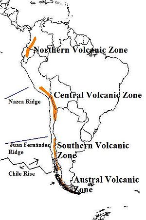
The andes mountains are one of the tallest. Map of the volcanic arcs in the Andes, and subducted structures affecting volcanism
The Andean Volcanic Belt is a major volcanic belt along the Andean cordillera in Argentina, Bolivia, Chile, Colombia, Ecuador, and Peru. It is formed as a result of subduction of the Nazca Plate and Antarctic Plate underneath the South American Plate. The belt is subdivided into four main volcanic zones which are separated by volcanic gaps. The volcanoes of the belt are diverse in terms of activity style, products, and morphology. While some differences can be explained by which volcanic zone a volcano belongs to, there are significant differences within volcanic zones and even between neighboring volcanoes. Despite being a type location for calc-alkalic and subduction volcanism, the Andean Volcanic Belt has a broad range of volcano-tectonic settings, as it has rift systems and extensional zones, transpressional faults, subduction of mid-ocean ridges and seamount chains as well as a large range of crustal thicknesses and magma ascent paths and different amounts of crustal assimilations.
Romeral in Colombia is the northernmost active member of the Andean Volcanic Belt. South of latitude 49° S within the Austral Volcanic Zone volcanic activity decreases with the southernmost volcano Fueguino in Tierra del Fuego archipelago. (Full article...) -
The Sierra Nevada del Cocuy Chita or Guican National Natural Park (or Sierra Nevada de Chita or Sierra Nevada de Güicán, Spanish: Parque Natural Sierra Nevada del Cocuy Chita o Guican is a national park and a series of highlands and glaciated peaks located within the Cordillera Oriental mountain range in the Andes Mountains of Colombia, at its easternmost point. It also corresponds to the highest range of the Eastern Cordillera and holds the biggest glacial mass in South America, north of the Equator. Since 1977, this region is protected within a National Natural Park (NNP-Cocuy) because of its fragile páramos, extraordinary bio-diversity and endemism, and its function as a corridor for migratory species under conditions of climate change. Among the Sierra’s natural attractions are the remaining 18 ice-covered peaks (there were as many as 25 in the recent past), glacial lakes and waterfalls. (Full article...) -
Misti is a dormant volcano located in the Andes mountains in southern Peru, rising above Peru's second-largest city, Arequipa. It is a conical volcano with two nested summit craters, the inner one of which contains a volcanic plug or lava dome with active fumaroles. The summit of the volcano lies on the margin of the outer crater and is 5,822 metres (19,101 ft) above sea level. Snow falls on the summit during the wet season, but does not persist; there are no glaciers. The upper slopes of the volcano are barren, while the lower slopes are covered by bushland.
The volcano developed over four different stages. During each stage, lava flows and lava domes built up a mountain, whose summit then collapsed to form a caldera. The volcano is part of a volcano group with Chachani to the northwest and Pichu Pichu to the southeast, and developed on top of a basement formed by numerous Miocene-Pliocene ignimbrites and volcano-derived debris. Numerous intense explosive eruptions took place during the last 50,000 years and covered the surrounding terrain with tephra. The last two significant eruptions were 2,000 years ago and in 1440–1470 AD; since then, phases of increased fumarolic activity have sometimes been mistaken for eruptions. (Full article...) -
Nevado Ojos del Salado is a dormant complex volcano in the Andes on the Argentina–Chile border. It is the highest volcano on Earth and the highest peak in Chile. The upper reaches of Ojos del Salado consist of several overlapping lava domes, lava flows and volcanic craters, with sparse ice cover. The complex extends over an area of 70–160 square kilometres (27–62 sq mi) and its highest summit reaches an altitude of 6,893 metres (22,615 ft) above sea level. Numerous other volcanoes rise around Ojos del Salado.
Being close to the Arid Diagonal of South America, the mountain has extremely dry conditions, which prevent the formation of substantial glaciers and a permanent snow cover. Despite the arid climate, there is a permanent crater lake about 100 m (330 ft) in diameter at an elevation of 6,480 metres (21,260 ft)-6,500 metres (21,300 ft) within the summit crater and east of the main summit. This is the highest lake of any kind in the world. Owing to its altitude and the desiccated climate, the mountain lacks vegetation. (Full article...) -
Pico Bonpland is Venezuela's third highest peak, at 4,883 metres above sea level. It is located in the Sierra Nevada de Merida, in the Venezuelan Andes of (Mérida State). The peak with its sister peak Pico Humboldt, and the surrounding páramos are protected by the Sierra Nevada National Park. The name of the peak is in honor of Aimé Bonpland, although he never visited the Venezuelan Andes.
The glaciers located in the Bonpland were the result from Merida glaciation in the Pleistocene. By 2011 they had all disappeared. (Full article...) -
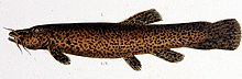
Trichomycterus rivulatus is a species of pencil catfish that is native to high-altitude Andean streams and lakes (including Junin, Poopó and Titicaca) in southern Peru, western Bolivia and northern Chile. It is the largest species in the genus Trichomycterus and grows to a maximum length of 37.4 centimetres (14.7 in) TL. The species is regularly caught as a food fish. However, because of pollution, studies have revealed levels of metals in T. rivulatus of Lake Titicaca that exceed the internationally recommended safety thresholds for human consumption. (Full article...) -
Chumpe (possibly from Quechua chumpi: belt), Jatunriti, Ñanaloma or Yanaloma is a mountain in the Vilcanota mountain range in the Andes of Peru with 6,106 metres (20,033 ft) of elevation. It is located in the Cusco Region, Canchis Province, Pitumarca District as well as in the Quispicanchi Province, Ocongate District. Chumpe lies north of Lake Sibinacocha. (Full article...)
![Image 1 Steam on the mountain in July 2007 Nevado del Ruiz (Spanish pronunciation: [neβaðo ðel ˈrwis]), also known as La Mesa de Herveo (English: Mesa of Herveo, the name of the nearby town) is a volcano on the border of the departments of Caldas and Tolima in Colombia, about 129 km (80 mi) west of the capital city Bogotá. It is a stratovolcano composed of many layers of lava alternating with hardened volcanic ash and other pyroclastic rocks. Volcanic activity at Nevado del Ruiz began about two million years ago, during the Early Pleistocene or Late Pliocene, with three major eruptive periods. The current volcanic cone formed during the present eruptive period, which began 150,000 years ago. The volcano usually generates Vulcanian to Plinian eruptions, which produce swift-moving currents of hot gas and rock called pyroclastic flows. These eruptions often cause massive lahars (mud and debris flows), which pose a threat to human life and the environment. The impact of such an eruption is increased as the hot gas and lava melt the mountain's snowcap, adding large quantities of water to the flow. On November 13, 1985, a small eruption produced an enormous lahar that buried and destroyed the town of Armero in Tolima, causing an estimated 25,000 deaths. This event later became known as the Armero tragedy—the deadliest lahar in recorded history. Similar but less deadly incidents occurred in 1595 and 1845, consisting of a small explosive eruption followed by a large lahar. (Full article...)](http://oksuvcw.org/?page_id=192&rdp_we_resource=https%3A%2F%2Fen.wikipedia.org%2Fwiki%2FFile%3ABlank.png)


Did you know...
- ... that the 1930s Polish Andean expeditions have been credited with several first ascents and the tracing of a new route to the summit of Aconcagua, the Andes' highest peak?
Need help?
Do you have a question about Andes that you can't find the answer to?
Consider asking it at the Wikipedia reference desk.
General images
-

-
 Ulluco: Common crop of the Andean region (from Andean agriculture)
 -
 Central Andes (from Andes)
 -
 Map of a north-south sea-parallel pattern of rock ages in western Colombia. This pattern is a result of the Andean orogeny. (from Andean orogeny)
 -
 Frederic Edwin Church, Heart of the Andes, 1859. (from Andes)
 -

-
 Mashua tubers (from Andean agriculture)
 -

-

-

-
 Pico Humboldt at sunset (from Andes)
 -
 Irrigating land in the Peruvian Andes (from Andes)
 -
 Peruvian farmers sowing maize and beans (from Andes)
 -
 Bolivian Andes (from Andes)
 -
 Nevado del Huila, Colombia (from Andes)
 -
 View of Cuernos del Paine in Torres del Paine National Park, Chile (from Andes)
 -
 Parinacota, Bolivia/Chile (from Andes)
 -

-
 Map of the Andean region of South America (from Andean agriculture)
 -

-
 Pacha Mama Ceremony (from Andean agriculture)
 -
 The seaward tilting of the sedimentary strata of Salto del Fraile Formation in Peru was caused by the Andean orogeny. (from Andean orogeny)
 -

-
 Syncline next to Nordenskjöld Lake in Torres del Paine National Park. The syncline formed during the Andean orogeny. (from Andean orogeny)
 -
 Aerial view of Valle Carbajal in the Tierra del Fuego. The Andes range is about 200 km (124 mi) wide throughout its length, except in the Bolivian flexure where it is about 640 kilometres (398 mi) wide. (from Andes)
 -
 Paleogeography of the Late Cretaceous South America. Areas subject to the Andean orogeny are shown in light grey while the stable cratons are shown as grey squares. The sedimentary formations of Los Alamitos and La Colonia that formed in the Late Cretaceous are indicated. (from Andean orogeny)
 -
 Topographic map of the Andes by the NASA. The southern and northern ends of the Andes are not shown. The Bolivian Orocline is visible as a bend in the coastline and the Andes lower half of the map. (from Andean orogeny)
 -

-
 A male Andean cock-of-the-rock, a species found in humid Andean forests and the national bird of Peru (from Andes)
 -
 Simplified sketch of the present-situation along most of the Andes (from Andean orogeny)
 -
 Laguna de Sonso tropical dry forest in Northern Andes (from Andes)
 -

-


Subcategories

- Select [►] to view subcategories
Related portals
Subtopics
Associated Wikimedia
The following Wikimedia Foundation sister projects provide more on this subject:
-
 Commons
Free media repository -
 Wikibooks
Free textbooks and manuals -
 Wikidata
Free knowledge base -
 Wikinews
Free-content news -
 Wikiquote
Collection of quotations -
 Wikisource
Free-content library -
 Wikiversity
Free learning tools -
 Wiktionary
Dictionary and thesaurus
-

-

-

-

-

-

-

-

-

-

-
 Random portal
 -


Purge server cache