

Skútustaðahreppur (Icelandic pronunciation: [ˈskuːtʏˌstaːðaˌr̥ɛhpʏr̥] ⓘ, regionally also [ˈskuːtʰʏ-]) is a former rural municipality located in East Iceland, in Northeastern Region. Its seat was in the village of Reykjahlíð.[1] In 2022 the municipality merged with Þingeyjarsveit under the name of the latter.[2]
Geography
Skútustaðir was one of the largest Icelandic municipalities. Its southern borders were represented by the northern site of the glacier of Vatnajökull. Its territory included the lakes of Mývatn (in front of Reykjahlíð) and Öskjuvatn; and the volcanoes of Hverfjall, Askja, Krafla and Herðubreið.
Gallery
-
 Mývatn Nature Baths
 -
 The Drekagil (canyon of dragons) in Askja
 -
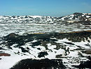 Aerial view of Krafla


References
- ^ "Google Earth". earth.google.com. Retrieved 2020-10-17.
- ^ "Skútustaðahreppur og Þingeyjarsveit sameinast". Vikublaðið (in Icelandic).
External links
![]() Media related to Skútustaðahreppur at Wikimedia Commons
Media related to Skútustaðahreppur at Wikimedia Commons
- Official website (in Icelandic)