

No higher resolution available.
Planes_trains_automobiles_route_map.gif (357 × 297 pixels, file size: 19 KB, MIME type: image/gif)

|
This fictional map image could be re-created using vector graphics as an SVG file. This has several advantages; see Commons:Media for cleanup for more information. If an SVG form of this image is available, please upload it and afterwards replace this template with
{{vector version available|new image name}}.
It is recommended to name the SVG file “Planes trains automobiles route map.svg”—then the template Vector version available (or Vva) does not need the new image name parameter. |
| Description |
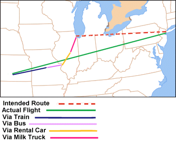
English: Route taken by Del Griffin and Neal Page in the movie Planes, Trains and Automobiles
Summary
|
| Date | |
| Source | File:Map of USA without state names.svg |
| Author | Ichabod |
| Other versions | Derivative works of this file: Planes trains automobiles route map FR.png |
Licensing
I, the copyright holder of this work, hereby publish it under the following licenses:
This file is licensed under the Creative Commons Attribution-Share Alike 3.0 Unported license.
- You are free:
- to share – to copy, distribute and transmit the work
- to remix – to adapt the work
- Under the following conditions:
- attribution – You must give appropriate credit, provide a link to the license, and indicate if changes were made. You may do so in any reasonable manner, but not in any way that suggests the licensor endorses you or your use.
- share alike – If you remix, transform, or build upon the material, you must distribute your contributions under the same or compatible license as the original.

|
Permission is granted to copy, distribute and/or modify this document under the terms of the GNU Free Documentation License, Version 1.2 or any later version published by the Free Software Foundation; with no Invariant Sections, no Front-Cover Texts, and no Back-Cover Texts. A copy of the license is included in the section entitled GNU Free Documentation License. |
You may select the license of your choice.
File history
Click on a date/time to view the file as it appeared at that time.
| Date/Time | Thumbnail | Dimensions | User | Comment | |
|---|---|---|---|---|---|
| current | 23:05, 28 December 2009 | | 357 × 297 (19 KB) | Ichabod | {{Information |Description={{en|1=== Summary == {{Information |Description={{en|1=Route taken by Del Griffin and Neal Page in the movie Planes, Trains and Automobiles ==Summary== * Red dotted line - Intended route Ne |
File usage
The following pages on the English Wikipedia use this file (pages on other projects are not listed):
Global file usage
The following other wikis use this file:
- Usage on de.wikipedia.org
- Usage on hu.wikipedia.org
- Usage on ro.wikipedia.org
- Usage on ru.wikipedia.org
- Usage on sh.wikipedia.org