


Size of this preview: 676 × 600 pixels. Other resolutions: 271 × 240 pixels | 541 × 480 pixels | 866 × 768 pixels | 1,155 × 1,024 pixels | 1,600 × 1,419 pixels.
Original file (1,600 × 1,419 pixels, file size: 679 KB, MIME type: image/jpeg)
Summary
| Description |
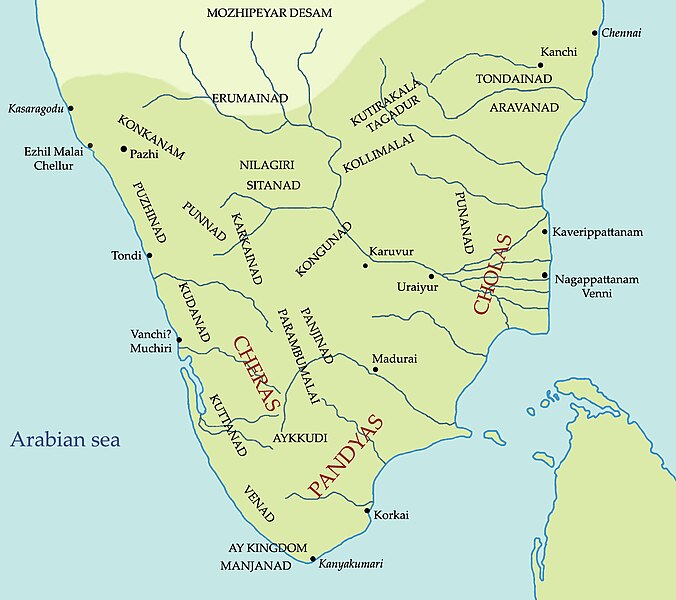
English: South India in Sangam Period, based on the chart in "A Survey Of Kerala History" by A Sreedhara Menon |
| Date | |
| Source | Own work |
| Author | Yon Man33 |
Licensing
I, the copyright holder of this work, hereby publish it under the following license:
This file is licensed under the Creative Commons Attribution-Share Alike 3.0 Unported license.
- You are free:
- to share – to copy, distribute and transmit the work
- to remix – to adapt the work
- Under the following conditions:
- attribution – You must give appropriate credit, provide a link to the license, and indicate if changes were made. You may do so in any reasonable manner, but not in any way that suggests the licensor endorses you or your use.
- share alike – If you remix, transform, or build upon the material, you must distribute your contributions under the same or compatible license as the original.
File history
Click on a date/time to view the file as it appeared at that time.
| Date/Time | Thumbnail | Dimensions | User | Comment | |
|---|---|---|---|---|---|
| current | 14:13, 4 August 2013 | | 1,600 × 1,419 (679 KB) | Copperchloride | Reverted to version as of 19:37, 15 July 2013 POV racking. |
| 18:59, 2 August 2013 |  | 1,600 × 1,419 (745 KB) | SriSuren | Named the unanmed territories. For explaination see description. | |
| 19:37, 15 July 2013 |  | 1,600 × 1,419 (679 KB) | Obi2canibe | content of map changed without proper explanation | |
| 23:39, 14 July 2013 |  | 1,600 × 1,419 (745 KB) | SriSuren | Named the territories | |
| 23:32, 14 July 2013 |  | 1,600 × 1,419 (745 KB) | SriSuren | Named the territories | |
| 13:13, 8 March 2012 |  | 1,600 × 1,419 (679 KB) | Yon Man33 |
File usage
The following pages on the English Wikipedia use this file (pages on other projects are not listed):
Global file usage
The following other wikis use this file:
- Usage on ar.wikipedia.org
- Usage on ast.wikipedia.org
- Usage on bh.wikipedia.org
- Usage on bn.wikipedia.org
- Usage on de.wikipedia.org
- Usage on es.wikipedia.org
- Usage on fa.wikipedia.org
- Usage on hi.wikipedia.org
- Usage on id.wikipedia.org
- Usage on it.wikipedia.org
- Usage on ja.wikipedia.org
- Usage on ko.wikipedia.org
- Usage on ml.wikipedia.org
- Usage on ne.wikipedia.org
- Usage on ru.wikipedia.org
- Usage on sl.wikipedia.org
- Usage on ta.wikipedia.org
- Usage on te.wikipedia.org
- Usage on ur.wikipedia.org
- Usage on www.wikidata.org