


Size of this PNG preview of this SVG file: 800 × 563 pixels. Other resolutions: 320 × 225 pixels | 640 × 450 pixels | 1,024 × 720 pixels | 1,280 × 900 pixels | 2,560 × 1,801 pixels | 2,977 × 2,094 pixels.
Original file (SVG file, nominally 2,977 × 2,094 pixels, file size: 113 KB)
Summary
| Description |
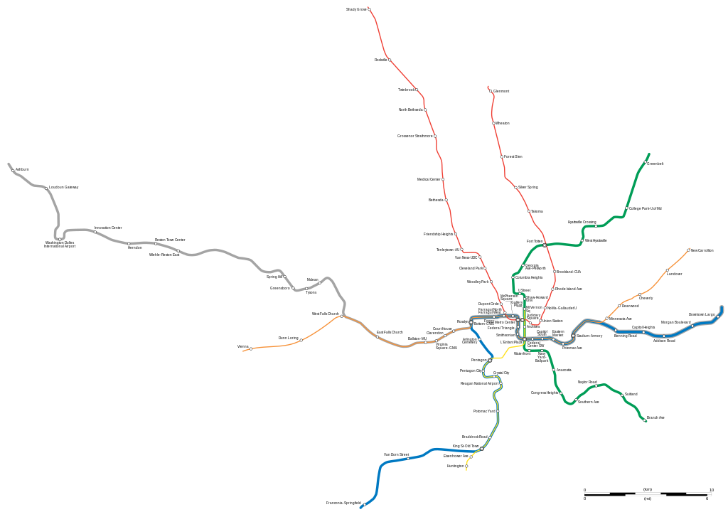
English: Map of the Washington Metrorail system, done to actual scale reflecting the status 2023.
|
||||||||||||||||||||
| Date | |||||||||||||||||||||
| Source |
Own work based on:
|
||||||||||||||||||||
| Author | Goran_tek-en | ||||||||||||||||||||
| Permission (Reusing this file) |
This file is licensed under the Creative Commons Attribution-Share Alike 4.0 International license. Attribution: Goran_tek-en
|
||||||||||||||||||||
| Other versions |
|
||||||||||||||||||||
| SVG development | This vector image was created with Inkscape. |
||||||||||||||||||||
.svg)
File history
Click on a date/time to view the file as it appeared at that time.
| Date/Time | Thumbnail | Dimensions | User | Comment | |
|---|---|---|---|---|---|
| current | 13:05, 31 December 2023 | | 2,977 × 2,094 (113 KB) | Goran tek-en | {{Information |description ={{en|Map of the Washington Metrorail system, done to actual scale reflecting the status 2023.}} {{Institution |wikidata=Qx}} |date =2023-12-31 |source ={{Own based|Washington DC Metro Map (To Scale).svg|b1=Noclip}} <br> {{own using}} [https://www.openstreetmap.org/query?lat=38.9047&lon=-77.1880#map=12/38.8365/-77.0346&layers=T OpenStreetMap transportlayer]<br> Information from: *[https://www.wmata.com/schedules/maps/... |
File usage
The following pages on the English Wikipedia use this file (pages on other projects are not listed):
Global file usage
The following other wikis use this file:
- Usage on de.wikipedia.org
- Usage on eo.wikipedia.org
- Usage on es.wikipedia.org
- Usage on fr.wikipedia.org
- Usage on it.wikipedia.org
- Usage on ka.wikipedia.org
- Usage on kk.wikipedia.org
- Usage on ko.wikipedia.org
- Usage on la.wikipedia.org
- Usage on ru.wikipedia.org
- Usage on simple.wikipedia.org
- Usage on th.wikipedia.org
- Usage on tr.wikipedia.org
- Usage on uk.wikipedia.org
.svg)