


Size of this preview: 800 × 489 pixels. Other resolutions: 320 × 196 pixels | 640 × 391 pixels | 883 × 540 pixels.
Original file (883 × 540 pixels, file size: 194 KB, MIME type: image/jpeg)
Summary
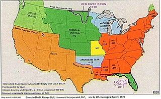
| Description | Cropped version of map. | |||
| Date | ||||
| Source | File:USA Territorial Growth 1820 alt.jpg | |||
| Author | US Geological Survey, visually reorganized by User:Beyond My Ken and cropped by User:White whirlwind. | |||
| Permission (Reusing this file) |
|
File history
Click on a date/time to view the file as it appeared at that time.
| Date/Time | Thumbnail | Dimensions | User | Comment | |
|---|---|---|---|---|---|
| current | 19:30, 6 June 2019 | | 883 × 540 (194 KB) | White whirlwind | {{Information |description=Cropped version of map. |date=6 June 2019 |source=File:USA Territorial Growth 1820 alt.jpg |author=US Geological Survey, visually reorganized by User:Beyond My Ken and cropped by User:White whirlwind. |permission={{PD-USGov-USGS}} |other versions= }} |
File usage
The following pages on the English Wikipedia use this file (pages on other projects are not listed):
Global file usage
The following other wikis use this file:
- Usage on ca.wikipedia.org
- Usage on da.wikipedia.org