

Cowdrey is an unincorporated community with a U.S. Post Office in Jackson County, Colorado, United States. The Cowdrey Post Office has the ZIP Code 80434.[2]
Geography
Cowdrey is located at 40°51′30″N 106°18′45″W / 40.85833°N 106.31250°W (40.858227,-106.312637).
Climate
| Climate data for Cowdrey (CoAgMet), Colorado, 2010–2022 normals: 7895ft (2406m) | |||||||||||||
|---|---|---|---|---|---|---|---|---|---|---|---|---|---|
| Month | Jan | Feb | Mar | Apr | May | Jun | Jul | Aug | Sep | Oct | Nov | Dec | Year |
| Mean daily maximum °F (°C) | 28.6 (−1.9) |
31.1 (−0.5) |
42.2 (5.7) |
49.5 (9.7) |
59.0 (15.0) |
71.8 (22.1) |
77.5 (25.3) |
77.8 (25.4) |
72.0 (22.2) |
55.4 (13.0) |
42.4 (5.8) |
30.6 (−0.8) |
53.2 (11.8) |
| Daily mean °F (°C) | 12.4 (−10.9) |
15.9 (−8.9) |
26.1 (−3.3) |
33.8 (1.0) |
43.2 (6.2) |
54.5 (12.5) |
58.8 (14.9) |
55.3 (12.9) |
48.4 (9.1) |
35.9 (2.2) |
25.6 (−3.6) |
14.7 (−9.6) |
35.4 (1.9) |
| Mean daily minimum °F (°C) | −3.8 (−19.9) |
0.6 (−17.4) |
9.9 (−12.3) |
18.0 (−7.8) |
27.4 (−2.6) |
37.0 (2.8) |
40.0 (4.4) |
32.7 (0.4) |
24.7 (−4.1) |
16.4 (−8.7) |
8.7 (−12.9) |
−1.2 (−18.4) |
17.5 (−8.0) |
| Source 1: XMACIS2[3] | |||||||||||||
| Source 2: CoAgMet[4] | |||||||||||||
See also
References
- ^ a b "US Board on Geographic Names". United States Geological Survey. October 25, 2007. Retrieved January 31, 2008.
- ^ a b "ZIP Code Lookup". United States Postal Service. December 15, 2006. Archived from the original (JavaScript/HTML) on November 22, 2010. Retrieved December 15, 2006.
- ^ "xmACIS2". National Oceanic and Atmospheric Administration. Retrieved December 9, 2023.
- ^ "Info for Cowdrey (COW01)". Colorado State University. Retrieved December 9, 2023.
External links
![]() Media related to Coudrey, Colorado at Wikimedia Commons
Media related to Coudrey, Colorado at Wikimedia Commons
Municipalities and communities of Jackson County, Colorado, United States | ||
|---|---|---|
| Town | 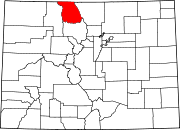 | |
| Unincorporated communities | ||