

Content deleted Content added
Andrew Gwilliam (talk | contribs) m →Current listings: Punctuation. Spelling. Capitalisation. |
Ser Amantio di Nicolao (talk | contribs) →top: add short description Tag: AWB |
||
| (23 intermediate revisions by 16 users not shown) | |||
| Line 1: | Line 1: | ||
{{short description|None}} |
|||
__NOTOC__ |
__NOTOC__ |
||
[[File:Map of Oklahoma highlighting Choctaw County.svg|thumb|Location of Choctaw County in Oklahoma]] |
[[File:Map of Oklahoma highlighting Choctaw County.svg|thumb|Location of Choctaw County in Oklahoma]] |
||
This is a list of the '''National Register of Historic Places listings in Choctaw County, Oklahoma'''. |
This is a list of the '''National Register of Historic Places listings in Choctaw County, Oklahoma'''. |
||
This is intended to be a complete list of the properties and districts on the [[National Register of Historic Places]] in [[Choctaw County, Oklahoma|Choctaw County]], [[Oklahoma]], [[United States]]. The locations of National Register properties and districts for which the latitude and longitude coordinates are included below, may be seen in a |
This is intended to be a complete list of the properties and districts on the [[National Register of Historic Places]] in [[Choctaw County, Oklahoma|Choctaw County]], [[Oklahoma]], [[United States]]. The locations of National Register properties and districts for which the latitude and longitude coordinates are included below, may be seen in a map.<ref>{{NRHPGoogleMapFootnote}}</ref> |
||
There are 13 properties and districts listed on the National Register in the county. |
There are 13 properties and districts listed on the National Register in the county. |
||
{{NRHP date for lists|Oklahoma}} |
{{NRHP date for lists|Oklahoma}} |
||
{{ |
{{GeoGroup}}{{Clear}} |
||
{{Oklahoma county NRHP navbox}} |
|||
==Current listings== |
==Current listings== |
||
{{NRHP header|NRISref=2009a|state_iso=us-ok}} |
|||
{|class="wikitable sortable" style="width:98%" |
|||
{{NRHP row |
|||
! {{NRHP color}}|<ref name=colorlegend>Numbers represent an ordering by significant words. Various colorings, defined [[Wikipedia:NRHP colors legend|here]], differentiate [[National Historic Landmark]] sites and [[National Register of Historic Places Districts]] from other NRHP buildings, structures, sites or objects.</ref> |
|||
|pos=1 |
|||
! width = 18% {{NRHP color}}| '''Landmark name'''<ref name=nris>{{NRISref|2009a}}</ref> |
|||
|refnum=71000660 |
|||
! width = 8% class="unsortable" {{NRHP color}}| '''Image''' |
|||
|type=NRHP |
|||
! width = 10% {{NRHP color}}|'''Date listed''' |
|||
|article=District Choctaw Chief's House |
|||
! {{NRHP color}}|'''Location''' |
|||
|name=Chief's House |
|||
! width = 8% {{NRHP color}}|'''City or Town''' |
|||
|address=1.5 miles northeast of Swink |
|||
! class="unsortable" {{NRHP color}}| '''Summary''' |
|||
|city=[[Swink, Oklahoma|Swink]] |
|||
|-- |
|||
|county=[[Choctaw County, Oklahoma]] |
|||
! {{NRHP color}} | <small>1</small> |
|||
|date=1971-06-21 |
|||
| [[District Choctaw Chief's House]] |
|||
|image= |
|||
| <!-- Image goes here --> |
|||
|lat=34.023056 |
|||
| {{dts|1971|6|21}} |
|||
|lon=-95.181667 |
|||
| 1.5 miles northeast of Swink<br/><small>{{coord|34|1|23|N|95|10|54|W|name=Chief's House}}</small> |
|||
|description=Built for the Appuckshunubbe District Chief, the 1830 Treaty of Dancing Rabbit Creek provided for its construction. This house at Swink is the only house still on its original site in existence from that era. Maintained by the Swink Historical Preservation Association, it is open by appointment. (2011) |
|||
| [[Swink, Oklahoma|Swink]] |
|||
}} |
|||
| Built for the Appuckshunubbe District Chief, the 1830 Treaty of Dancing Rabbit Creek provided for its construction. This house at Swink is the only house still on its original site in existence from that era. Maintained by the Swink Historical Preservation Association, it is open by appointment. (2011) |
|||
{{NRHP row |
|||
|-- |
|||
|pos=2 |
|||
! {{NRHP color}} | <small>2</small> |
|||
|refnum=75001561 |
|||
| [[Doaksville Site]] |
|||
|type=NRHP |
|||
| <!-- Image goes here --> |
|||
|article=Doaksville Site |
|||
| {{dts|1975|5|29}} |
|||
|name=Doaksville Site |
|||
| Address Restricted |
|||
|address=Address Restricted |
|||
| [[Fort Towson, Oklahoma|Fort Towson]] |
|||
|city=[[Fort Towson, Oklahoma|Fort Towson]] |
|||
| <!-- Description goes here --> |
|||
|county=[[Choctaw County, Oklahoma]] |
|||
|-- |
|||
|date=1975-05-29 |
|||
! {{NRHP color}} | <small>3</small> |
|||
|image= |
|||
| [[Everidge Cabin and Cemetery]] |
|||
|lat= |
|||
| <!-- Image goes here --> |
|||
|lon= |
|||
| {{dts|1982|3|31}} |
|||
|description=<!-- Description goes here --> |
|||
| Off the railroad line<br/><small>{{coord|33|56|34|N|95|21|19|W|name=Everidge Cabin and Cemetery}}</small> |
|||
}} |
|||
| [[Hugo, Oklahoma|Hugo]] |
|||
{{NRHP row |
|||
| <!-- Description goes here --> |
|||
|pos=3 |
|||
|-- |
|||
|refnum=82003674 |
|||
! {{HD color}} | <small>4</small> |
|||
|type=NRHP |
|||
| [[Fort Towson]] |
|||
|article=Everidge Cabin and Cemetery |
|||
| <!-- Image goes here --> |
|||
|name=Everidge Cabin and Cemetery |
|||
| {{dts|1970|9|29}} |
|||
|address=Off the railroad line |
|||
| 1 miles northeast of Fort Towson<br/><small>{{coord|34|1|34|N|95|15|8|W|name=Fort Towson}}</small> |
|||
| |
|city=[[Hugo, Oklahoma|Hugo]] |
||
|county=[[Choctaw County, Oklahoma]] |
|||
| <!-- Description goes here --> |
|||
|date=1982-03-31 |
|||
|-- |
|||
|image= |
|||
! {{NRHP color}} | <small>5</small> |
|||
|lat=33.942778 |
|||
| [[Hugo Armory]] |
|||
|lon=-95.355278 |
|||
| <!-- Image goes here --> |
|||
|description=<!-- Description goes here --> |
|||
| {{dts|1988|9|8}} |
|||
}} |
|||
| Jefferson and 3rd Sts.<br/><small>{{coord|34|0|30|N|95|30|36|W|name=Hugo Armory}}</small> |
|||
{{NRHP row |
|||
| [[Hugo, Oklahoma|Hugo]] |
|||
|pos=4 |
|||
| <!-- Description goes here --> |
|||
|refnum=70000531 |
|||
|-- |
|||
|type=HD |
|||
! {{NRHP color}} | <small>6</small> |
|||
|article=Fort Towson |
|||
| [[Hugo Frisco Railroad Depot]] |
|||
|name=Fort Towson |
|||
| <!-- Image goes here --> |
|||
|address=1 mile northeast of Fort Towson |
|||
| {{dts|1980|6|6}} |
|||
|city=[[Fort Towson, Oklahoma|Fort Towson]] |
|||
| N. A and Jackson Sts.<br/><small>{{coord|34|0|43|N|95|30|53|W|name=Hugo Frisco Railroad Depot}}</small> |
|||
| |
|county=[[Choctaw County, Oklahoma]] |
||
|date=1970-09-29 |
|||
| <!-- Description goes here --> |
|||
|image= |
|||
|-- |
|||
|lat=34.026111 |
|||
! {{HD color}} | <small>7</small> |
|||
|lon=-95.252222 |
|||
| [[Hugo Historic District]] |
|||
| |
|description=<!-- Description goes here --> |
||
}} |
|||
| {{dts|1980|11|12}} |
|||
{{NRHP row |
|||
| U.S. Routes [[U.S. Route 70|70]] and [[U.S. Route 271|271]]<br/><small>{{coord|34|0|39.12|N|95|30|46.31|W|name=Hugo Historic District}}</small> |
|||
|pos=5 |
|||
| [[Hugo, Oklahoma|Hugo]] |
|||
|refnum=88001378 |
|||
| <!-- Description goes here --> |
|||
|type=NRHP |
|||
|-- |
|||
|article=Hugo Armory |
|||
! {{NRHP color}} | <small>8</small> |
|||
|name=Hugo Armory |
|||
| [[Choctaw County Public Library]] |
|||
|address=Jefferson and 3rd Sts. |
|||
| <!-- Image goes here --> |
|||
|city=[[Hugo, Oklahoma|Hugo]] |
|||
| {{dts|1988|9|8}} |
|||
|county=[[Choctaw County, Oklahoma]] |
|||
| 703 E. Jackson St. |
|||
|date=1988-09-08 |
|||
| Hugo, Oklahoma 74743|Hugo]] |
|||
|image=Hugo March 2016 12 (Hugo Armory).jpg |
|||
| Built in 2004 with a Donlad W. Reynolds Foundation grant,it is a Southeastern Public Library System of Oklahoma Branch. |
|||
|lat=34.008333 |
|||
|-- |
|||
|lon=-95.51 |
|||
! {{NRHP color}} | <small>9</small> |
|||
|description=<!-- Description goes here --> |
|||
| [[Rose Hill Plantation (Hugo, Oklahoma)|Rose Hill Plantation]] |
|||
|commonscat=Hugo Armory |
|||
| <!-- Image goes here --> |
|||
}} |
|||
| {{dts|2010|3|15}} |
|||
{{NRHP row |
|||
| Address Restricted |
|||
|pos=6 |
|||
| [[Hugo, Oklahoma|Hugo]] |
|||
|refnum=80003259 |
|||
| <!-- Description goes here --> |
|||
|type=NRHP |
|||
|-- |
|||
|article=Hugo Frisco Railroad Depot |
|||
! {{NRHP color}} | <small>10</small> |
|||
|name=Hugo Frisco Railroad Depot |
|||
| [[Speer School]] |
|||
|address=N. A and Jackson Sts. |
|||
| <!-- Image goes here --> |
|||
|city=[[Hugo, Oklahoma|Hugo]] |
|||
| {{dts|1988|9|8}} |
|||
|county=[[Choctaw County, Oklahoma]] |
|||
| Off [[U.S. Route 271]] east on a county road<br/><small>{{coord|34|6|49|N|95|32|54|W|name=Speer School}}</small> |
|||
|date=1980-06-06 |
|||
| [[Hugo, Oklahoma|Hugo]] |
|||
|image=Hugo Frisco Depot Museum March 2016 01.jpg |
|||
| <!-- Description goes here --> |
|||
|lat=34.011944 |
|||
|-- |
|||
|lon=-95.514722 |
|||
! {{NRHP color}} | <small>11</small> |
|||
|description=<!-- Description goes here --> |
|||
| [[Spencer Academy]] |
|||
|commonscat=Frisco Depot Museum (Hugo, Oklahoma) |
|||
| <!-- Image goes here --> |
|||
}} |
|||
| {{dts|1975|5|21}} |
|||
{{NRHP row |
|||
| 10 miles north of Fort Towson<br/><small>{{coord|34|8|51|N|95|21|37|W|name=Spencer Academy}}</small> |
|||
|pos=7 |
|||
| [[Fort Towson, Oklahoma|Fort Towson]] |
|||
|refnum=80003260 |
|||
| <!-- Description goes here --> |
|||
|type=HD |
|||
|-- |
|||
|article=Hugo Historic District |
|||
! {{NRHP color}} | <small>12</small> |
|||
|name=Hugo Historic District |
|||
| [[Spencerville School Campus]] |
|||
|address=U.S. Routes [[U.S. Route 70 in Oklahoma|70]] and [[U.S. Route 271 (Oklahoma)|271]] |
|||
| <!-- Image goes here --> |
|||
|city=[[Hugo, Oklahoma|Hugo]] |
|||
| {{dts|1988|9|8}} |
|||
|county=[[Choctaw County, Oklahoma]] |
|||
| South of Spencerville<br/><small>{{coord|34|8|31|N|95|22|13|W|name=Spencerville School Campus}}</small> |
|||
|date=1980-11-12 |
|||
| [[Spencerville, Oklahoma|Spencerville]] |
|||
|image=Hugo March 2016 09 (Broadway Street).jpg |
|||
| <!-- Description goes here --> |
|||
|lat=34.010867 |
|||
|-- |
|||
|lon=-95.512864 |
|||
! {{NRHP color}} | <small>13</small> |
|||
|description=<!-- Description goes here --> |
|||
| [[Willie W. Wilson House]] |
|||
|commonscat=Hugo Historic District |
|||
| <!-- Image goes here --> |
|||
}} |
|||
| {{dts|1982|4|20}} |
|||
{{NRHP row |
|||
| Northeastern corner of the junction of Cincinnati Ave. and Main St.<br/><small>{{coord|34|1|15.132|N|95|15|55.476|W|name=Wilson, Willie W., House}}</small> |
|||
|pos=8 |
|||
| [[Fort Towson, Oklahoma|Fort Towson]] |
|||
|refnum=88001379 |
|||
| <!-- Description goes here --> |
|||
|type=NRHP |
|||
|article=Hugo Public Library |
|||
|name=Hugo Public Library |
|||
|address=703 E. Jackson St. |
|||
|city=[[Hugo, Oklahoma|Hugo]] |
|||
|county=[[Choctaw County, Oklahoma]] |
|||
|date=1988-09-08 |
|||
|image=<!--- photo of NRHP-listed building wanted ---> |
|||
|lat=34.0108 |
|||
|lon=-95.5048 |
|||
|description=Building replaced by the Choctaw County Public Library in 2004. |
|||
}} |
|||
{{NRHP row |
|||
|pos=9 |
|||
|refnum=10000069 |
|||
|type=NRHP |
|||
|article=Rose Hill Plantation (Hugo, Oklahoma) |
|||
|name=Rose Hill Plantation |
|||
|address=Address Restricted |
|||
|city=[[Hugo, Oklahoma|Hugo]] |
|||
|county=[[Choctaw County, Oklahoma]] |
|||
|date=2010-03-15 |
|||
|image=Cemetery_at_Rose_Hill_Plantation.jpg |
|||
|lat= |
|||
|lon= |
|||
|description=<!-- Description goes here --> |
|||
}} |
|||
{{NRHP row |
|||
|pos=10 |
|||
|refnum=88001380 |
|||
|type=NRHP |
|||
|article=Speer School |
|||
|name=Speer School |
|||
|address=Off [[U.S. Route 271]] east on a county road |
|||
|city=[[Hugo, Oklahoma|Hugo]] |
|||
|county=[[Choctaw County, Oklahoma]] |
|||
|date=1988-09-08 |
|||
|image= |
|||
|lat=34.113611 |
|||
|lon=-95.548333 |
|||
|description=<!-- Description goes here --> |
|||
}} |
|||
{{NRHP row |
|||
|pos=11 |
|||
|refnum=75001562 |
|||
|type=NRHP |
|||
|article=Spencer Academy |
|||
|name=Spencer Academy |
|||
|address=10 miles north of Fort Towson |
|||
|city=[[Fort Towson, Oklahoma|Fort Towson]] |
|||
|county=[[Choctaw County, Oklahoma]] |
|||
|date=1975-05-21 |
|||
|image= |
|||
|lat=34.1475 |
|||
|lon=-95.360278 |
|||
|description=<!-- Description goes here --> |
|||
}} |
|||
{{NRHP row |
|||
|pos=12 |
|||
|refnum=88001381 |
|||
|type=NRHP |
|||
|article=Spencerville School Campus |
|||
|name=Spencerville School Campus |
|||
|address=South of Spencerville |
|||
|city=[[Spencerville, Oklahoma|Spencerville]] |
|||
|county=[[Choctaw County, Oklahoma]] |
|||
|date=1988-09-08 |
|||
|image= |
|||
|lat=34.141944 |
|||
|lon=-95.370278 |
|||
|description=<!-- Description goes here --> |
|||
}} |
|||
{{NRHP row |
|||
|pos=13 |
|||
|refnum=82003673 |
|||
|type=NRHP |
|||
|article=Willie W. Wilson House |
|||
|name=Willie W. Wilson House |
|||
|address=Northeastern corner of the junction of Cincinnati Ave. and Main St. |
|||
|city=[[Fort Towson, Oklahoma|Fort Towson]] |
|||
|county=[[Choctaw County, Oklahoma]] |
|||
|date=1982-04-20 |
|||
|image= |
|||
|lat=34.02087 |
|||
|lon=-95.26541 |
|||
|description=<!-- Description goes here --> |
|||
}} |
|||
|} |
|} |
||
==See also== |
==See also== |
||
{{Commons category|National Register of Historic Places in Choctaw County, Oklahoma}} |
|||
* [[List of National Historic Landmarks in Oklahoma]] |
* [[List of National Historic Landmarks in Oklahoma]] |
||
* [[National Register of Historic Places listings in Oklahoma]] |
* [[National Register of Historic Places listings in Oklahoma]] |
||
| Line 132: | Line 223: | ||
{{reflist}} |
{{reflist}} |
||
{{NRHP in Choctaw County, Oklahoma}} |
|||
{{National Register of Historic Places}} |
{{National Register of Historic Places}} |
||
{{Choctaw County, Oklahoma}} |
{{Choctaw County, Oklahoma}} |
||
[[Category:Choctaw County, Oklahoma| ]] |
[[Category:Choctaw County, Oklahoma| ]] |
||
[[Category:National Register of Historic Places in Oklahoma by county|Choctaw County]] |
[[Category:Lists of National Register of Historic Places in Oklahoma by county|Choctaw County]] |
||
[[Category:Buildings and structures in Choctaw County, Oklahoma]] |
[[Category:Buildings and structures in Choctaw County, Oklahoma]] |
||
[[Category:National Register of Historic Places in Choctaw County, Oklahoma|*]] |
|||
Latest revision as of 19:16, 5 March 2022

This is a list of the National Register of Historic Places listings in Choctaw County, Oklahoma.
This is intended to be a complete list of the properties and districts on the National Register of Historic Places in Choctaw County, Oklahoma, United States. The locations of National Register properties and districts for which the latitude and longitude coordinates are included below, may be seen in a map.[1]
There are 13 properties and districts listed on the National Register in the county.
This National Park Service list is complete through NPS recent listings posted April 26, 2024.[2]
Current listings
| [3] | Name on the Register[4] | Image | Date listed[5] | Location | City or town | Description |
|---|---|---|---|---|---|---|
| 1 | Chief's House | June 21, 1971 (#71000660) |
1.5 miles northeast of Swink 34°01′23″N 95°10′54″W / 34.023056°N 95.181667°W | Swink | Built for the Appuckshunubbe District Chief, the 1830 Treaty of Dancing Rabbit Creek provided for its construction. This house at Swink is the only house still on its original site in existence from that era. Maintained by the Swink Historical Preservation Association, it is open by appointment. (2011) | |
| 2 | Doaksville Site | May 29, 1975 (#75001561) |
Address Restricted | Fort Towson | ||
| 3 | Everidge Cabin and Cemetery | March 31, 1982 (#82003674) |
Off the railroad line 33°56′34″N 95°21′19″W / 33.942778°N 95.355278°W | Hugo | ||
| 4 | Fort Towson | September 29, 1970 (#70000531) |
1 mile northeast of Fort Towson 34°01′34″N 95°15′08″W / 34.026111°N 95.252222°W | Fort Towson | ||
| 5 | Hugo Armory |  |
September 8, 1988 (#88001378) |
Jefferson and 3rd Sts. 34°00′30″N 95°30′36″W / 34.008333°N 95.51°W | Hugo | |
| 6 | Hugo Frisco Railroad Depot |  |
June 6, 1980 (#80003259) |
N. A and Jackson Sts. 34°00′43″N 95°30′53″W / 34.011944°N 95.514722°W | Hugo | |
| 7 | Hugo Historic District |  |
November 12, 1980 (#80003260) |
U.S. Routes 70 and 271 34°00′39″N 95°30′46″W / 34.010867°N 95.512864°W | Hugo | |
| 8 | Hugo Public Library | September 8, 1988 (#88001379) |
703 E. Jackson St. 34°00′39″N 95°30′17″W / 34.0108°N 95.5048°W | Hugo | Building replaced by the Choctaw County Public Library in 2004. | |
| 9 | Rose Hill Plantation |  |
March 15, 2010 (#10000069) |
Address Restricted | Hugo | |
| 10 | Speer School | September 8, 1988 (#88001380) |
Off U.S. Route 271 east on a county road 34°06′49″N 95°32′54″W / 34.113611°N 95.548333°W | Hugo | ||
| 11 | Spencer Academy | May 21, 1975 (#75001562) |
10 miles north of Fort Towson 34°08′51″N 95°21′37″W / 34.1475°N 95.360278°W | Fort Towson | ||
| 12 | Spencerville School Campus | September 8, 1988 (#88001381) |
South of Spencerville 34°08′31″N 95°22′13″W / 34.141944°N 95.370278°W | Spencerville | ||
| 13 | Willie W. Wilson House | April 20, 1982 (#82003673) |
Northeastern corner of the junction of Cincinnati Ave. and Main St. 34°01′15″N 95°15′55″W / 34.02087°N 95.26541°W | Fort Towson |
See also
- List of National Historic Landmarks in Oklahoma
- National Register of Historic Places listings in Oklahoma
References
- ^ The latitude and longitude information provided in this table was derived originally from the National Register Information System, which has been found to be fairly accurate for about 99% of listings. Some locations in this table may have been corrected to current GPS standards.
- ^ National Park Service, United States Department of the Interior, "National Register of Historic Places: Weekly List Actions", retrieved April 26, 2024.
- ^ Numbers represent an alphabetical ordering by significant words. Various colorings, defined here, differentiate National Historic Landmarks and historic districts from other NRHP buildings, structures, sites or objects.
- ^ "National Register Information System". National Register of Historic Places. National Park Service. March 13, 2009.
- ^ The eight-digit number below each date is the number assigned to each location in the National Register Information System database, which can be viewed by clicking the number.
| Topics | |
|---|---|
| Lists by state |
|
| Lists by insular areas | |
| Lists by associated state | |
| Other areas | |
| Related | |
Municipalities and communities of Choctaw County, Oklahoma, United States | ||
|---|---|---|
| City | 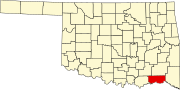 | |
| Towns | ||
| CDPs | ||
| Other unincorporated communities | ||
| Indian reservation | ||
| Footnotes | ‡This populated place also has portions in another county or counties | |