Contents
Content deleted Content added
BotMultichill (talk | contribs) m Converting list to use Template:NRHP header and Template:NRHP row |
Multichill (talk | contribs) →Listings: county field |
||
| Line 14: | Line 14: | ||
|address=In the [[Pacific Ocean|North Pacific]] |
|address=In the [[Pacific Ocean|North Pacific]] |
||
|city=[[Wake Island]] |
|city=[[Wake Island]] |
||
|county= |
|county=[[Wake Island]] |
||
|date=1985-09-16 |
|date=1985-09-16 |
||
|image=Wake Island.png |
|image=Wake Island.png |
||
| Line 29: | Line 29: | ||
|address=Sand and Eastern Islands |
|address=Sand and Eastern Islands |
||
|city=[[Midway Atoll]] |
|city=[[Midway Atoll]] |
||
|county= |
|county=[[Midway Atoll]] |
||
|date=1987-05-28 |
|date=1987-05-28 |
||
|image=Battle of Midway (Japanese air raid).jpg |
|image=Battle of Midway (Japanese air raid).jpg |
||
Revision as of 17:55, 17 December 2011

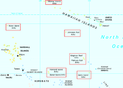
This is a list of the buildings, sites, districts, and objects listed on the National Register of Historic Places across the United States Minor Outlying Islands. There are currently two listed sites located on two of the twelve islands or atolls that make up the Minor Outlying Islands.
This National Park Service list is complete through NPS recent listings posted April 12, 2024.[1]
Listings
| [2] | Name on the Register | Image | Date listed[3] | Location | City or town | Description |
|---|---|---|---|---|---|---|
| 1 | Wake Island |  |
September 16, 1985 (#85002726) |
In the North Pacific 19°18′00″N 166°38′00″E / 19.3°N 166.633333°E | Wake Island | |
| 2 | World War II Facilities at Midway |  |
May 28, 1987 (#87001302) |
Sand and Eastern Islands 28°12′N 177°21′E / 28.2°N 177.35°E | Midway Atoll |
See also
References
- ^ National Park Service, United States Department of the Interior, "National Register of Historic Places: Weekly List Actions", retrieved April 12, 2024.
- ^ Numbers represent an alphabetical ordering by significant words. Various colorings, defined here, differentiate National Historic Landmarks and historic districts from other NRHP buildings, structures, sites or objects.
- ^ The eight-digit number below each date is the number assigned to each location in the National Register Information System database, which can be viewed by clicking the number.

