


Size of this preview: 800 × 600 pixels. Other resolutions: 320 × 240 pixels | 640 × 480 pixels | 1,024 × 768 pixels | 1,280 × 960 pixels | 2,560 × 1,920 pixels | 3,264 × 2,448 pixels.
Original file (3,264 × 2,448 pixels, file size: 3.02 MB, MIME type: image/jpeg)
Summary
| Description |
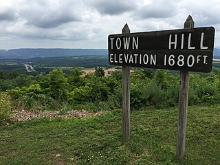
English: View of the entrance sign and beyond towards Interstate 68 and U.S. Route 40 (National Freeway) at the Town Hill Overlook on Town Hill in eastern Allegany County, Maryland |
| Date | |
| Source | Own work |
| Author | Famartin |
| Camera location | | View this and other nearby images on: OpenStreetMap |
|---|
_at_the_Town_Hill_Overlook_on_Town_Hill_in_eastern_Allegany_County,_Maryland.jpg¶ms=039.698056_N_-078.400886_E_globe:Earth_type:camera_heading:290.86&language=en)
Licensing
I, the copyright holder of this work, hereby publish it under the following license:
This file is licensed under the Creative Commons Attribution-Share Alike 4.0 International license.
- You are free:
- to share – to copy, distribute and transmit the work
- to remix – to adapt the work
- Under the following conditions:
- attribution – You must give appropriate credit, provide a link to the license, and indicate if changes were made. You may do so in any reasonable manner, but not in any way that suggests the licensor endorses you or your use.
- share alike – If you remix, transform, or build upon the material, you must distribute your contributions under the same or compatible license as the original.
File history
Click on a date/time to view the file as it appeared at that time.
| Date/Time | Thumbnail | Dimensions | User | Comment | |
|---|---|---|---|---|---|
| current | 16:19, 14 November 2016 | | 3,264 × 2,448 (3.02 MB) | Famartin | User created page with UploadWizard |
File usage
The following pages on the English Wikipedia use this file (pages on other projects are not listed):
Global file usage
The following other wikis use this file:
- Usage on www.wikidata.org
_at_the_Town_Hill_Overlook_on_Town_Hill_in_eastern_Allegany_County,_Maryland.jpg)