

Size of this JPG preview of this PDF file: 463 × 599 pixels. Other resolutions: 185 × 240 pixels | 371 × 480 pixels | 593 × 768 pixels | 1,275 × 1,650 pixels.
Original file (1,275 × 1,650 pixels, file size: 2.37 MB, MIME type: application/pdf)
Summary
| Description |
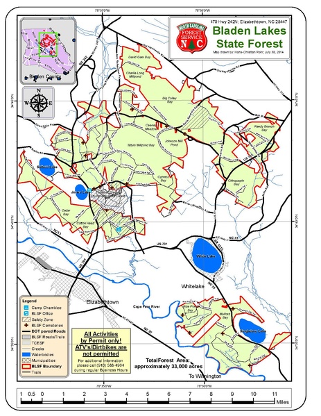
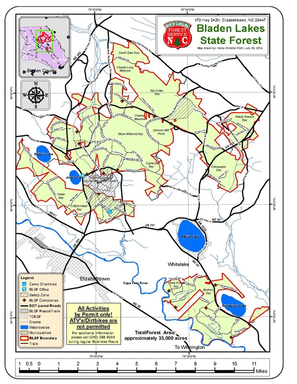
English: This is a map of Bladen Lakes State Forest. It shows the boundaries and the main roads, waterways cemeteries and camping site within the State Forest. |
| Date | The map was last updated in 2015 |
| Source |
I created this map as part of my work reqirements |
| Author | Ellchen1 |
Licensing
I, the copyright holder of this work, hereby publish it under the following licenses:

|
Permission is granted to copy, distribute and/or modify this document under the terms of the GNU Free Documentation License, Version 1.2 or any later version published by the Free Software Foundation; with no Invariant Sections, no Front-Cover Texts, and no Back-Cover Texts. A copy of the license is included in the section entitled GNU Free Documentation License. |
This file is licensed under the Creative Commons Attribution-Share Alike 3.0 Unported license.
- You are free:
- to share – to copy, distribute and transmit the work
- to remix – to adapt the work
- Under the following conditions:
- attribution – You must give appropriate credit, provide a link to the license, and indicate if changes were made. You may do so in any reasonable manner, but not in any way that suggests the licensor endorses you or your use.
- share alike – If you remix, transform, or build upon the material, you must distribute your contributions under the same or compatible license as the original.
You may select the license of your choice.
File history
Click on a date/time to view the file as it appeared at that time.
| Date/Time | Thumbnail | Dimensions | User | Comment | |
|---|---|---|---|---|---|
| current | 15:12, 25 August 2015 |  | 1,275 × 1,650 (2.37 MB) | Ellchen1 | {{subst:Upload marker added by en.wp UW}} {{Information |Description = {{en|This is a map of Bladen Lakes State Forest. It shows the boundaries and the main roads, waterways cemeteries and camping site within the State Forest.}} |Source = I created th... |
File usage
The following pages on the English Wikipedia use this file (pages on other projects are not listed):