


Size of this JPG preview of this TIF file: 431 × 600 pixels. Other resolutions: 172 × 240 pixels | 345 × 480 pixels | 552 × 768 pixels | 736 × 1,024 pixels | 1,472 × 2,048 pixels | 3,702 × 5,151 pixels.
Original file (3,702 × 5,151 pixels, file size: 18.19 MB, MIME type: image/tiff)
Summary
| - Castillo de San Felipe del Morro, Northwest end of San Juan, San Juan, San Juan Municipio, PR | ||||
|---|---|---|---|---|
| Title |
- Castillo de San Felipe del Morro, Northwest end of San Juan, San Juan, San Juan Municipio, PR |
|||
| Description |
Antonelli, Juan Baustista; de Salazar, Pedro; Price, Gigi B, transmitter; Klugh, T, transmitter; Behrens, Tom, transmitter; Boucher, Jack E, photographer; Price, Virginia B, transmitter |
|||
| Depicted place | Puerto Rico; San Juan Municipio; San Juan | |||
| Date | 1998 | |||
| Dimensions | 5 x 7 in. | |||
| Current location |
Library of Congress Prints and Photographs Division Washington, D.C. 20540 USA http://hdl.loc.gov/loc.pnp/pp.print |
|||
| Accession number |
HABS PR,7-SAJU,6-102 |
|||
| Credit line |
|
|||
| Notes |
|
|||
| References |
|
|||
| Source | https://www.loc.gov/pictures/item/pr0076.photos.206211p | |||
| Permission (Reusing this file) |
|
|||

| Object location | | View this and other nearby images on: OpenStreetMap |
|---|
File history
Click on a date/time to view the file as it appeared at that time.
| Date/Time | Thumbnail | Dimensions | User | Comment | |
|---|---|---|---|---|---|
| current | 11:21, 1 August 2014 | 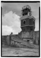 | 3,702 × 5,151 (18.19 MB) | Fæ | GWToolset: Creating mediafile for Fæ. HABS 31 July 2014 (3000:3200) |
File usage
The following pages on the English Wikipedia use this file (pages on other projects are not listed):