

Size of this preview: 800 × 296 pixels. Other resolutions: 320 × 118 pixels | 640 × 236 pixels | 1,024 × 378 pixels | 1,280 × 473 pixels | 4,285 × 1,583 pixels.
Original file (4,285 × 1,583 pixels, file size: 2.47 MB, MIME type: image/jpeg)
|
This is an image of a place or building that is listed on the National Register of Historic Places in the United States of America. Its reference number is 66000420. |
Summary
| Description |
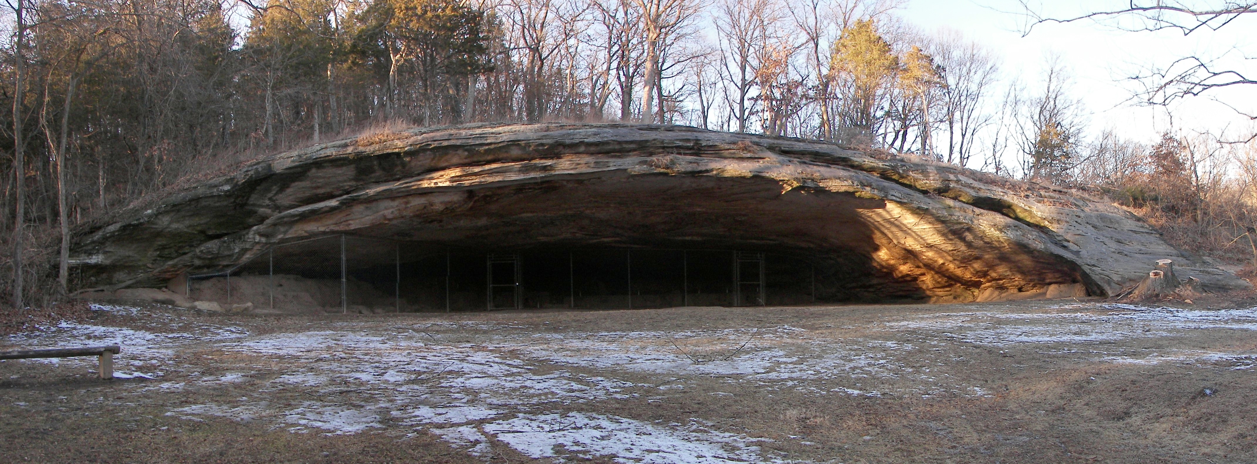
English: Graham Cave is a Native American archaeological site near Mineola, Missouri in Montgomery County. The entrance of the sandstone cave forms a broad arch 120 feet (37 m) wide and 16 feet (5 m) high. Extending about 100 feet (30 m) into the hillside, the cave protects an historically important Pre-Columbian achaeological site from the ancient Dalton and Archaic period dating back to as early as 10,000 years ago.
This image is a panoramic composite of four photographs taken with a Kodak P850 digital camera. The panorama was created with the software program "hugin". |
| Date | |
| Source | Own work |
| Author | Kbh3rd |
| Camera location | | View this and other nearby images on: OpenStreetMap |
|---|
Licensing
I, the copyright holder of this work, hereby publish it under the following licenses:
This file is licensed under the Creative Commons Attribution-Share Alike 3.0 Unported license.
- You are free:
- to share – to copy, distribute and transmit the work
- to remix – to adapt the work
- Under the following conditions:
- attribution – You must give appropriate credit, provide a link to the license, and indicate if changes were made. You may do so in any reasonable manner, but not in any way that suggests the licensor endorses you or your use.
- share alike – If you remix, transform, or build upon the material, you must distribute your contributions under the same or compatible license as the original.

|
Permission is granted to copy, distribute and/or modify this document under the terms of the GNU Free Documentation License, Version 1.2 or any later version published by the Free Software Foundation; with no Invariant Sections, no Front-Cover Texts, and no Back-Cover Texts. A copy of the license is included in the section entitled GNU Free Documentation License. |
You may select the license of your choice.
This image was created with Hugin.
File history
Click on a date/time to view the file as it appeared at that time.
| Date/Time | Thumbnail | Dimensions | User | Comment | |
|---|---|---|---|---|---|
| current | 04:06, 9 February 2013 | 4,285 × 1,583 (2.47 MB) | Kbh3rd | Contrast adjusted; exif data expanded | |
| 02:28, 1 February 2009 | 4,285 × 1,583 (1.45 MB) | Kbh3rd | {{Information |Description={{en|1=Graham Cave is a Native American archaeological site near Mineola, Missouri in [[:en:Montgomery |
File usage
The following pages on the English Wikipedia use this file (pages on other projects are not listed):
Global file usage
The following other wikis use this file:
- Usage on ceb.wikipedia.org
- Usage on de.wikipedia.org
- Usage on fr.wikipedia.org
- Usage on www.wikidata.org