


Size of this preview: 800 × 538 pixels. Other resolutions: 320 × 215 pixels | 640 × 430 pixels | 1,024 × 688 pixels | 1,280 × 860 pixels | 2,560 × 1,720 pixels | 7,657 × 5,145 pixels.
Original file (7,657 × 5,145 pixels, file size: 15.67 MB, MIME type: image/jpeg)
Summary
| Artist |
James Cook |
| Description |
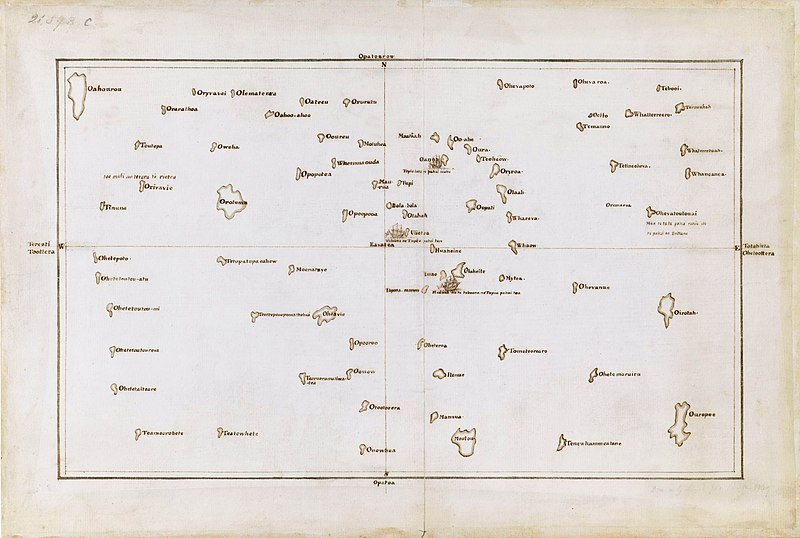
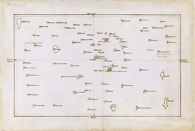
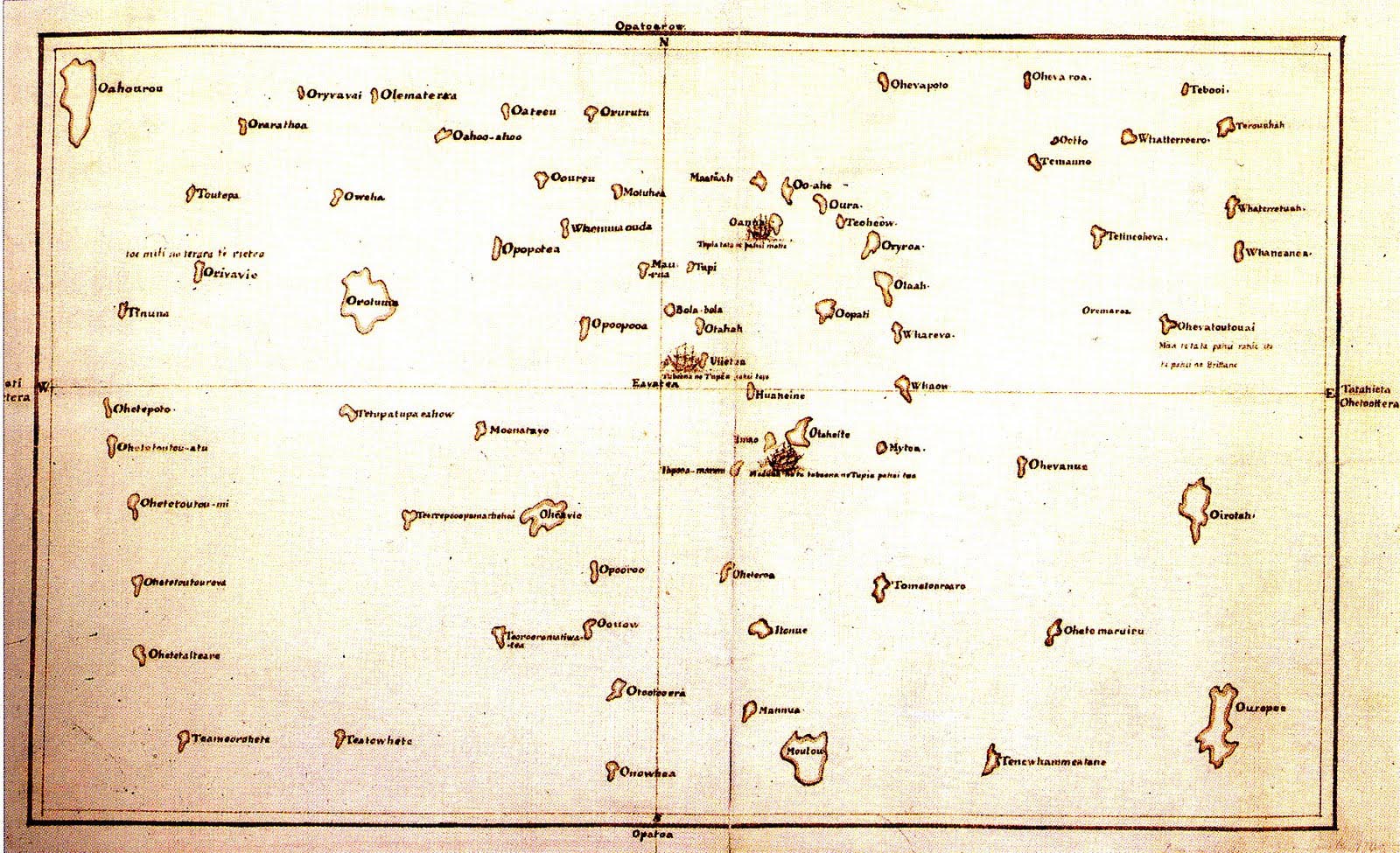
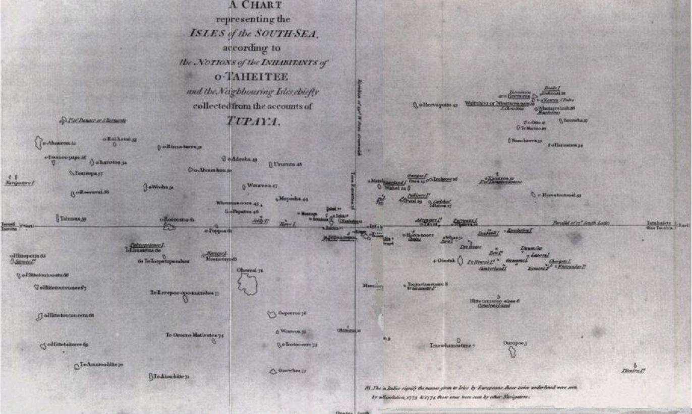
English: Tupaia's chart of the islands surrounding Tahiti in Oceania |
| Date | circa 1769 |
| Accession number |
Add MS 21593 C |
| References | The Society Islands |
| Source/Photographer |
British Library, London. |
Licensing
|
This is a faithful photographic reproduction of a two-dimensional, public domain work of art. The work of art itself is in the public domain for the following reason:
The official position taken by the Wikimedia Foundation is that "faithful reproductions of two-dimensional public domain works of art are public domain".
This photographic reproduction is therefore also considered to be in the public domain in the United States. In other jurisdictions, re-use of this content may be restricted; see Reuse of PD-Art photographs for details. | ||||
File history
Click on a date/time to view the file as it appeared at that time.
| Date/Time | Thumbnail | Dimensions | User | Comment | |
|---|---|---|---|---|---|
| current | 02:03, 23 September 2021 | | 7,657 × 5,145 (15.67 MB) | Capmo | Cropped 4 % horizontally, 6 % vertically using CropTool with lossless mode. |
| 00:15, 7 December 2019 |  | 8,000 × 5,484 (15.06 MB) | Adjutor | Newer image from the British Library https://www.bl.uk/collection-items/the-society-islands accessed 07 December 2019. Format - Pen and Ink, Map; Creator - James Cook, Tupaia Add. MS 21593 C; Created 1769 "This is a view of the Society Islands by Captain James Cook, who completed his first exploration of the Pacific Ocean from 1769 to 1771. The chart is a copy of an original document by Tupaia, a priest and leader of the island of Ra’iatea. He was enlisted by Cook to navigate HMS Endeavour to... | |
| 02:50, 16 March 2017 |  | 1,600 × 975 (371 KB) | KAVEBEAR | ||
| 02:46, 16 March 2017 |  | 801 × 488 (84 KB) | KAVEBEAR |
File usage
The following pages on the English Wikipedia use this file (pages on other projects are not listed):
Global file usage
The following other wikis use this file:
- Usage on de.wikipedia.org
- Usage on es.wikipedia.org
- Usage on id.wikipedia.org
- Usage on it.wikipedia.org
- Usage on no.wikipedia.org
- Usage on zh.wikipedia.org