


Size of this preview: 800 × 532 pixels. Other resolutions: 320 × 213 pixels | 640 × 426 pixels | 1,024 × 681 pixels | 1,280 × 851 pixels | 3,008 × 2,000 pixels.
Original file (3,008 × 2,000 pixels, file size: 2.97 MB, MIME type: image/jpeg)
|
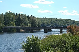
This is an image of a place or building that is listed on the National Register of Historic Places in the United States of America. Its reference number is 99001530. |
Summary
| Description |
English: The original Peshekee River Bridge listed on the National Register of Historic Places in Michigamme Township, Michigan, USA that carried US 41/M-28 in the 1920s and 1930s. |
| Date | |
| Source | Own work |
| Author | Imzadi1979 |
| Camera location | | View this and other nearby images on: OpenStreetMap |
|---|
Licensing
I, the copyright holder of this work, hereby publish it under the following license:
This file is licensed under the Creative Commons Attribution-Share Alike 3.0 Unported license.
- You are free:
- to share – to copy, distribute and transmit the work
- to remix – to adapt the work
- Under the following conditions:
- attribution – You must give appropriate credit, provide a link to the license, and indicate if changes were made. You may do so in any reasonable manner, but not in any way that suggests the licensor endorses you or your use.
- share alike – If you remix, transform, or build upon the material, you must distribute your contributions under the same or compatible license as the original.
File history
Click on a date/time to view the file as it appeared at that time.
| Date/Time | Thumbnail | Dimensions | User | Comment | |
|---|---|---|---|---|---|
| current | 21:09, 29 August 2008 | | 3,008 × 2,000 (2.97 MB) | Imzadi1979 | {{Information |Description={{en|1=The original Peshekee River Bridge listed on the National Register of Historic Places in Michigamme Township, Michigan, USA that carried US 41/M-28 until 1995.}} |Source=Own work by uploader |Author=[[User:Imzadi1979|Imza |
File usage
The following pages on the English Wikipedia use this file (pages on other projects are not listed):
- List of bridges on the National Register of Historic Places in Michigan
- M-28 (Michigan highway)
- National Register of Historic Places listings in Marquette County, Michigan
- Peshekee River
- Trunk Line Bridge No. 1
- U.S. Route 41 in Michigan
- Portal:Michigan highways/Did you know
- Portal:Michigan highways/Did you know/April 2012
- Portal:Michigan highways/Pictures
- Portal:Michigan highways/Selected picture/September 2012
- Portal:U.S. roads/Selected picture/Recommend/2010
Global file usage
The following other wikis use this file:
- Usage on ceb.wikipedia.org
- Usage on de.wikipedia.org
- Usage on ha.wikipedia.org
- Usage on uk.wikipedia.org
- Usage on www.wikidata.org