


Size of this preview: 745 × 600 pixels. Other resolutions: 298 × 240 pixels | 596 × 480 pixels | 954 × 768 pixels | 1,272 × 1,024 pixels | 2,544 × 2,048 pixels | 2,862 × 2,304 pixels.
Original file (2,862 × 2,304 pixels, file size: 1.01 MB, MIME type: image/jpeg)
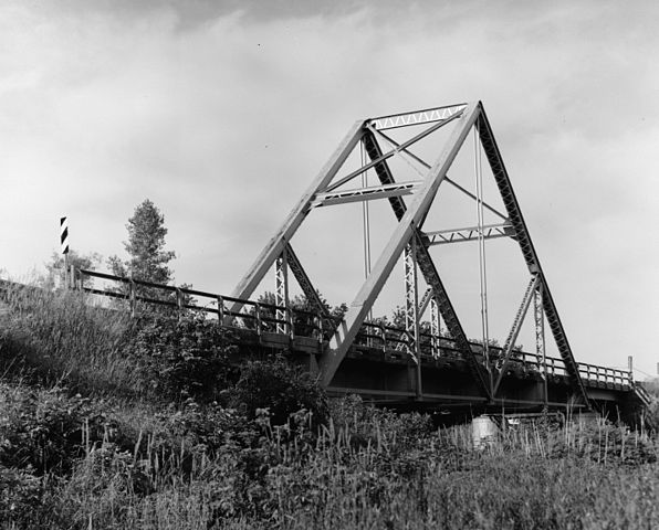
| Description | Cropped version of original, Waddell "A" Truss Bridge, Spanning Lin Branch Creek, Trimble vicinity, Clinton County, MO. (9. LONG DISTANCE GENERAL SIDE VIEW. HAER MO,25-TRIM.V,1-9) | ||||
| Date | Unknown date | ||||
| Source |
|
||||
| Author | Image taken by unknown photographer | ||||
| Permission (Reusing this file) |
|
||||
| Other versions | This a cropped version of Image:Waddell "A" Truss Bridge, Spanning Lin Branch Creek, Missouri.jpg |

File history
Click on a date/time to view the file as it appeared at that time.
| Date/Time | Thumbnail | Dimensions | User | Comment | |
|---|---|---|---|---|---|
| current | 14:04, 30 March 2007 | | 2,862 × 2,304 (1.01 MB) | Dual Freq | {{Information |Description=Cropped version of original, Waddell "A" Truss Bridge, Spanning Lin Branch Creek, Trimble vicinity, Clinton County, MO. (9. LONG DISTANCE GENERAL SIDE VIEW. HAER MO,25-TRIM.V,1-9) |Source=[http://memory.loc.gov/pnp/habshaer/mo/m |
File usage
The following pages on the English Wikipedia use this file (pages on other projects are not listed):
Global file usage
The following other wikis use this file:
- Usage on de.wikipedia.org
- Usage on es.wikipedia.org
- Usage on fr.wikipedia.org
- Usage on ja.wikipedia.org
- Usage on www.wikidata.org