


Size of this preview: 800 × 600 pixels. Other resolutions: 320 × 240 pixels | 640 × 480 pixels | 1,024 × 768 pixels | 1,280 × 960 pixels | 2,549 × 1,911 pixels.
Original file (2,549 × 1,911 pixels, file size: 3.49 MB, MIME type: image/jpeg)
|
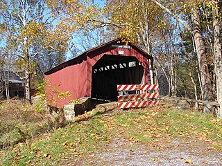
This is an image of a place or building that is listed on the National Register of Historic Places in the United States of America. Its reference number is 80003598. |
Summary
| Description |
English: Waggoner Covered Bridge on the NRHP since August 25, 1980. West of Loysville on Township 579 (nominally Wagoneers Road - but it is just a turnoff of PA 274, now Private property starting at the bridge). In Northeast Madison Township, Perry County, Pennsylvania. Interior used as a storage shed. Covered Bridge number 38-50-15. Built 1889, 74 feet in length, Burr arch. |
| Date | |
| Source | Own work |
| Author | Smallbones |
| Camera location | | View this and other nearby images on: OpenStreetMap |
|---|
Licensing
| I, the copyright holder of this work, release this work into the public domain. This applies worldwide. In some countries this may not be legally possible; if so: I grant anyone the right to use this work for any purpose, without any conditions, unless such conditions are required by law. |
File history
Click on a date/time to view the file as it appeared at that time.
| Date/Time | Thumbnail | Dimensions | User | Comment | |
|---|---|---|---|---|---|
| current | 18:25, 22 October 2010 | | 2,549 × 1,911 (3.49 MB) | Smallbones | {{Information |Description={{en|1=Waggoner Covered Bridge on the NRHP since August 25, 1980. West of Loysville on Township 579 (nominally Wagoneers Road - but it is just a turnoff of PA 274, now Private property starting at the bridge). In Northeast Madis |
File usage
The following pages on the English Wikipedia use this file (pages on other projects are not listed):
Global file usage
The following other wikis use this file:
- Usage on cy.wikipedia.org
- Usage on es.wikipedia.org
- Usage on tl.wikipedia.org
- Usage on uk.wikipedia.org
- Usage on ur.wikipedia.org
- Usage on vi.wikipedia.org
- Usage on www.wikidata.org