


Size of this preview: 800 × 600 pixels. Other resolutions: 320 × 240 pixels | 640 × 480 pixels | 1,024 × 768 pixels | 1,280 × 960 pixels | 2,560 × 1,920 pixels | 4,320 × 3,240 pixels.
Original file (4,320 × 3,240 pixels, file size: 2.78 MB, MIME type: image/jpeg)
|
This is an image of a place or building that is listed on the National Register of Historic Places in the United States of America. Its reference number is 78002373. |
Summary
| Description |
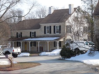
English: White Horse Tavern on the NRHP since December 29, 1978. Located northwest of Malvern at 480 Swedesford Road (renumbered to 606 Swedesford Road) On mile marker 24 on the Old Lancaster Road, overnight stop on the first stage from Philadelphia to Lancaster. General Washington used the older part (smaller-left) as his headquarters following Battle of Brandywine and during the aborted "Battle in the Clouds." Important stop for Washington's messenger from Valley Forge to Lancaster (temporary US capital). In East Whiteland Township, Chester County, Pennsylvania. North of US 30 and very near US 202. |
| Date | |
| Source | Own work |
| Author | Smallbones |
| Camera location | | View this and other nearby images on: OpenStreetMap |
|---|
Licensing
I, the copyright holder of this work, hereby publish it under the following license:
| This file is made available under the Creative Commons CC0 1.0 Universal Public Domain Dedication. | |
| The person who associated a work with this deed has dedicated the work to the public domain by waiving all of their rights to the work worldwide under copyright law, including all related and neighboring rights, to the extent allowed by law. You can copy, modify, distribute and perform the work, even for commercial purposes, all without asking permission.
|
File history
Click on a date/time to view the file as it appeared at that time.
| Date/Time | Thumbnail | Dimensions | User | Comment | |
|---|---|---|---|---|---|
| current | 01:25, 18 February 2011 | | 4,320 × 3,240 (2.78 MB) | Smallbones | {{Information |Description ={{en|1=White Horse Tavern on the NRHP since December 29, 1978. Located northwest of Malvern at 480 Swedesford Road (renumbered to 606 Swedesford Road) On mile marker 24 on the Old Lancaster Road, overnight stop on the first |
File usage
The following pages on the English Wikipedia use this file (pages on other projects are not listed):
Global file usage
The following other wikis use this file:
- Usage on fr.wikipedia.org
- Usage on uk.wikipedia.org
- Usage on www.wikidata.org