

Flintstone is an unincorporated community and census-designated place (CDP) in Allegany County, Maryland, United States. As of the 2010 census it had a population of 177.[3] It is part of the Cumberland, MD-WV Metropolitan Statistical Area.
Flintstone lies between the southern foot of Tussey Mountain and a water gap in Warrior Mountain formed by Flintstone Creek, a tributary of Town Creek, which flows south to the Potomac River. Flintstone is located just 1 mile (1.6 km) south of the Mason–Dixon line, the Maryland/Pennsylvania border. Rocky Gap State Park and Green Ridge State Forest are both in the Flintstone zip code. The Breakneck Road Historic District was listed on the National Register of Historic Places in 1980.[4]
-
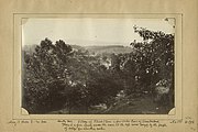 Flintstone in the 1860s

Demographics
| Census | Pop. | Note | %± |
|---|---|---|---|
| 2020 | 167 | — | |
| U.S. Decennial Census[5] | |||
References
- ^ "2020 U.S. Gazetteer Files". United States Census Bureau. Retrieved April 26, 2022.
- ^ a b U.S. Geological Survey Geographic Names Information System: Flintstone, Maryland
- ^ "Geographic Identifiers: 2010 Demographic Profile Data (G001): Flintstone CDP, Maryland". U.S. Census Bureau, American Factfinder. Archived from the original on February 12, 2020. Retrieved May 24, 2013.
- ^ "National Register Information System". National Register of Historic Places. National Park Service. April 15, 2008.
- ^ "Census of Population and Housing". Census.gov. Retrieved June 4, 2016.
