

Muñoz Rivera is a barrio in the municipality of Patillas, Puerto Rico. Its population in 2010 was 673.[3][4][5]
| Census | Pop. | Note | %± |
|---|---|---|---|
| 1900 | 1,080 | — | |
| 1910 | 933 | −13.6% | |
| 1920 | 1,109 | 18.9% | |
| 1930 | 926 | −16.5% | |
| 1940 | 1,215 | 31.2% | |
| 1950 | 1,311 | 7.9% | |
| 1960 | 1,043 | −20.4% | |
| 1970 | 715 | −31.4% | |
| 1980 | 567 | −20.7% | |
| 1990 | 904 | 59.4% | |
| 2000 | 743 | −17.8% | |
| 2010 | 673 | −9.4% | |
| U.S. Decennial Census 1899 (shown as 1900)[6] 1910-1930[7] 1930-1950[8] 1980-2000[9] 2010[10] | |||
Sectors
Barrios (which are, in contemporary times, roughly comparable to minor civil divisions)[11] in turn are further subdivided into smaller local populated place areas/units called sectores (sectors in English). The types of sectores may vary, from normally sector to urbanización to reparto to barriada to residencial, among others.[12][13][14]
The following sectors are in Muñoz Rivera barrio:[15]
Carretera 179, Carretera 184, Sector El Campamento Real, Sector Los Tres Chorros, Sector Miraflores, Sector Palma Sola, Sector Real, Sector Riachuelo, Sector Río Arriba, and Sector Sonadora.
Gallery
-
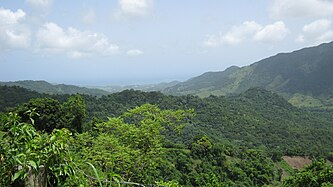 View facing Patillas Pueblo from PR-184
 -
 Puerto Rico Highway 184 in Muñoz Rivera


See also
References
- ^ a b "US Gazetteer 2019". US Census. US Government.
- ^ U.S. Geological Survey Geographic Names Information System: Muñoz Rivera barrio
- ^ Picó, Rafael; Buitrago de Santiago, Zayda; Berrios, Hector H. Nueva geografía de Puerto Rico: física, económica, y social, por Rafael Picó. Con la colaboración de Zayda Buitrago de Santiago y Héctor H. Berrios. San Juan Editorial Universitaria, Universidad de Puerto Rico,1969.
- ^ Gwillim Law (20 May 2015). Administrative Subdivisions of Countries: A Comprehensive World Reference, 1900 through 1998. McFarland. p. 300. ISBN 978-1-4766-0447-3. Retrieved 25 December 2018.
- ^ Puerto Rico: 2010 Population and Housing Unit Counts.pdf (PDF). U.S. Dept. of Commerce, Economics and Statistics Administration, U.S. Census Bureau. 2010.
- ^ "Report of the Census of Porto Rico 1899". War Department Office Director Census of Porto Rico. Archived from the original on July 16, 2017. Retrieved September 21, 2017.
- ^ "Table 3-Population of Municipalities: 1930 1920 and 1910" (PDF). United States Census Bureau. Archived (PDF) from the original on August 17, 2017. Retrieved September 21, 2017.
- ^ "Table 4-Area and Population of Municipalities Urban and Rural: 1930 to 1950" (PDF). United States Census Bureau. Archived (PDF) from the original on August 30, 2015. Retrieved September 21, 2014.
- ^ "Table 2 Population and Housing Units: 1960 to 2000" (PDF). United States Census Bureau. Archived (PDF) from the original on July 24, 2017. Retrieved September 21, 2017.
- ^ Puerto Rico: 2010 Population and Housing Unit Counts.pdf (PDF). U.S. Dept. of Commerce Economics and Statistics Administration U.S. Census Bureau. 2010. Archived (PDF) from the original on 2017-02-20. Retrieved 2019-08-02.
- ^ "US Census Barrio-Pueblo definition". factfinder.com. US Census. Archived from the original on 13 May 2017. Retrieved 5 January 2019.
- ^ "Agencia: Oficina del Coordinador General para el Financiamiento Socioeconómico y la Autogestión (Proposed 2016 Budget)". Puerto Rico Budgets (in Spanish). Retrieved 28 June 2019.
- ^ Rivera Quintero, Marcia (2014), El vuelo de la esperanza: Proyecto de las Comunidades Especiales Puerto Rico, 1997-2004 (first ed.), San Juan, Puerto Rico Fundación Sila M. Calderón, ISBN 978-0-9820806-1-0
- ^ "Leyes del 2001". Lex Juris Puerto Rico (in Spanish). Retrieved 24 June 2020.
- ^ "PRECINTO ELECTORAL Patillas 091" (PDF). Comisión Estatal de Elecciones (in Spanish). Junta de Planificación - Gobierno de Puerto Rico. 22 September 2020. Retrieved 4 January 2021.