

The World Portal


The world is the totality of entities, the whole of reality, or everything that exists. The nature of the world has been conceptualized differently in different fields. Some conceptions see the world as unique while others talk of a "plurality of worlds". Some treat the world as one simple object while others analyze the world as a complex made up of parts.
In scientific cosmology, the world or universe is commonly defined as "[t]he totality of all space and time; all that is, has been, and will be". Theories of modality talk of possible worlds as complete and consistent ways how things could have been. Phenomenology, starting from the horizon of co-given objects present in the periphery of every experience, defines the world as the biggest horizon or the "horizon of all horizons". In philosophy of mind, the world is contrasted with the mind as that which is represented by the mind. Theology conceptualizes the world in relation to God, for example, as God's creation, as identical to God or as the two being interdependent. In religions, there is a tendency to downgrade the material or sensory world in favor of a spiritual world to be sought through religious practice. A comprehensive representation of the world and our place in it, as is found in religions, is known as a worldview. Cosmogony is the field that studies the origin or creation of the world while eschatology refers to the science or doctrine of the last things or of the end of the world.
In various contexts, the term "world" takes a more restricted meaning associated, for example, with the Earth and all life on it, with humanity as a whole or with an international or intercontinental scope. In this sense, world history refers to the history of humanity as a whole and world politics is the discipline of political science studying issues that transcend nations and continents. Other examples include terms such as "world religion", "world language", "world government", "world war", "world population", "world economy", or "world championship". (Full article...)
Selected articles -
-


An oryx in the Wildlife Reserve in Al Wusta in 2012. The reserve was formerly the Arabian Oryx Sanctuary, a UNESCO World Heritage Site that was delisted in 2007.
World Heritage Sites may lose their designation when the UNESCO World Heritage Committee determines that they are not properly managed or protected. The committee can place a site it is concerned about on its list of World Heritage in Danger of losing its designation, and attempts to negotiate with the local authorities to remedy the situation. If remediation fails, the committee then revokes its designation.
A country may also request to reduce the boundaries of one of its existing sites, in effect partially or fully delisting such properties. Under the World Heritage guidelines, a country must report to the committee whenever one of its properties "inscribed on the World Heritage List has seriously deteriorated, or when the necessary corrective measures have not been taken." (Full article...) -

The League of Nations (French: Société des Nations [sɔsjete de nɑsjɔ̃]) was the first worldwide intergovernmental organisation whose principal mission was to maintain world peace. It was founded on 10 January 1920 by the Paris Peace Conference that ended the First World War. The main organization ceased operations on 18 April 1946 when many of its components were relocated into the new United Nations. As the template for modern global governance, the League profoundly shaped the modern world.
The League's primary goals were stated in its eponymous Covenant. They included preventing wars through collective security and disarmament and settling international disputes through negotiation and arbitration. Its other concerns included labour conditions, just treatment of native inhabitants, human and drug trafficking, the arms trade, global health, prisoners of war, and protection of minorities in Europe. The Covenant of the League of Nations was signed on 28 June 1919 as Part I of the Treaty of Versailles, and it became effective with the rest of the Treaty on 10 January 1920. Australia was granted the right to participate as an autonomous member nation, marking the start of Australian independence on the global stage. The first meeting of the Council of the League took place on 16 January 1920, and the first meeting of the Assembly of the League took place on 15 November 1920. In 1919, U.S. president Woodrow Wilson won the Nobel Peace Prize for his role as the leading architect of the League. (Full article...) -

The wheel, invented sometime before the 4th millennium BC, is one of the most ubiquitous and important technologies. This detail of the "Standard of Ur", c. 2500 BCE., displays a Sumerian chariot.
The history of technology is the history of the invention of tools and techniques by humans. Technology includes methods ranging from as simple as stone tools to the complex genetic engineering and information technology that has emerged since the 1980s. The term technology comes from the Greek word techne, meaning art and craft, and the word logos, meaning word and speech. It was first used to describe applied arts, but it is now used to describe advancements and changes that affect the environment around us.
New knowledge has enabled people to create new things, and conversely, many scientific endeavors are made possible by technologies that assist humans in traveling to places they could not previously reach, and by scientific instruments by which we study nature in more detail than our natural senses allow. (Full article...) -

A world map on the Winkel tripel projection,
a low-error map projection adopted by the National Geographic Society for reference maps
A world map is a map of most or all of the surface of Earth. World maps, because of their scale, must deal with the problem of projection. Maps rendered in two dimensions by necessity distort the display of the three-dimensional surface of the Earth. While this is true of any map, these distortions reach extremes in a world map. Many techniques have been developed to present world maps that address diverse technical and aesthetic goals.
Charting a world map requires global knowledge of the Earth, its oceans, and its continents. From prehistory through the Middle Ages, creating an accurate world map would have been impossible because less than half of Earth's coastlines and only a small fraction of its continental interiors were known to any culture. With exploration that began during the European Renaissance, knowledge of the Earth's surface accumulated rapidly, such that most of the world's coastlines had been mapped, at least roughly, by the mid-1700s and the continental interiors by the twentieth century. (Full article...) -
The aftermath of World War II saw the rise of two global superpowers, the Soviet Union (USSR) and the United States (US). The aftermath of World War II was also defined by the rising threat of nuclear warfare, the creation and implementation of the United Nations as an intergovernmental organization, and the decolonization of Asia and Africa by European and East Asian powers, most notably by the United Kingdom, France, and Japan.
Once allies during World War II, the United States and the Soviet Union became competitors on the world stage and engaged in the Cold War, so called because it never resulted in overt, declared total war between the two powers. It was instead characterized by espionage, political subversion and proxy wars. Western Europe and Asia were rebuilt through the American Marshall Plan, whereas Central and Eastern Europe fell under the Soviet sphere of influence and eventually behind an "Iron Curtain". Europe was divided into a US-led Western Bloc and a USSR-led Eastern Bloc. Internationally, alliances with the two blocs gradually shifted, with some nations trying to stay out of the Cold War through the Non-Aligned Movement. The war also saw a nuclear arms race between the two superpowers; part of the reason that the Cold War never became a "hot" war was that the Soviet Union and the United States had nuclear deterrents against each other, leading to a mutually assured destruction standoff. (Full article...) -
The history of the Internet has its origin in the efforts of scientists and engineers to build and interconnect computer networks. The Internet Protocol Suite, the set of rules used to communicate between networks and devices on the Internet, arose from research and development in the United States and involved international collaboration, particularly with researchers in the United Kingdom and France.
Computer science was an emerging discipline in the late 1950s that began to consider time-sharing between computer users, and later, the possibility of achieving this over wide area networks. J. C. R. Licklider developed the idea of a universal network at the Information Processing Techniques Office (IPTO) of the United States Department of Defense (DoD) Advanced Research Projects Agency (ARPA). Independently, Paul Baran at the RAND Corporation proposed a distributed network based on data in message blocks in the early 1960s, and Donald Davies conceived of packet switching in 1965 at the National Physical Laboratory (NPL), proposing a national commercial data network in the United Kingdom. (Full article...) -

Global average temperatures show that the Medieval Warm Period was not a planet-wide phenomenon, and that the Little Ice Age was not a distinct planet-wide time period but rather the end of a long temperature decline that preceded recent global warming.
The temperature record of the last 2,000 years is reconstructed using data from climate proxy records in conjunction with the modern instrumental temperature record which only covers the last 170 years at a global scale. Large-scale reconstructions covering part or all of the 1st millennium and 2nd millennium have shown that recent temperatures are exceptional: the Intergovernmental Panel on Climate Change Fourth Assessment Report of 2007 concluded that "Average Northern Hemisphere temperatures during the second half of the 20th century were very likely higher than during any other 50-year period in the last 500 years and likely the highest in at least the past 1,300 years." The curve shown in graphs of these reconstructions is widely known as the hockey stick graph because of the sharp increase in temperatures during the last century. this broad pattern was supported by more than two dozen reconstructions, using various statistical methods and combinations of proxy records, with variations in how flat the pre-20th-century "shaft" appears. Sparseness of proxy records results in considerable uncertainty for earlier periods.
Individual proxy records, such as tree ring widths and densities used in dendroclimatology, are calibrated against the instrumental record for the period of overlap. Networks of such records are used to reconstruct past temperatures for regions: tree ring proxies have been used to reconstruct Northern Hemisphere extratropical temperatures (within the tropics trees do not form rings) but are confined to land areas and are scarce in the Southern Hemisphere which is largely ocean. Wider coverage is provided by multiproxy reconstructions, incorporating proxies such as lake sediments, ice cores and corals which are found in different regions, and using statistical methods to relate these sparser proxies to the greater numbers of tree ring records. The "Composite Plus Scaling" (CPS) method is widely used for large-scale multiproxy reconstructions of hemispheric or global average temperatures; this is complemented by Climate Field Reconstruction (CFR) methods which show how climate patterns have developed over large spatial areas, making the reconstruction useful for investigating natural variability and long-term oscillations as well as for comparisons with patterns produced by climate models. (Full article...)


General images -
-
 Standing Buddha from Gandhara, 2nd century CE
 -
 Olmec colossal head, now at the Museo de Antropología de Xalapa
 -
 A Benin Bronze head from Nigeria
 -

-
 A view of Earth with its global ocean and cloud cover, which dominate Earth's surface and hydrosphere; at Earth's polar regions, its hydrosphere forms larger areas of ice cover. (from Earth)
 -

-
 An animation of the changing density of productive vegetation on land (low in brown; heavy in dark green) and phytoplankton at the ocean surface (low in purple; high in yellow) (from Earth)
 -

-
 A composite image of artificial light emissions at night on a map of Earth (from Earth)
 -
 Japanese depiction of a Portuguese carrack. European maritime innovations led to proto-globalization.
 -

-
 Map of peopling of the world (Southern Dispersal paradigm), in thousands of years ago.
 -
 Artist's impression of Earth during the later Archean, the largely cooled planetary crust and water-rich barren surface, marked by volcanoes and continents, features already round microbialites. The Moon, still orbiting Earth much closer than today and still dominating Earth's sky, produced strong tides. (from History of Earth)
 -
An artist's impression of the Archean, the eon after Earth's formation, featuring round stromatolites, which are early oxygen-producing forms of life from billions of years ago. After the Late Heavy Bombardment, Earth's crust had cooled, its water-rich barren surface is marked by continents and volcanoes, with the Moon still orbiting Earth half as far as it is today, appearing 2.8 times larger and producing strong tides. (from Earth)
-
 Pale orange dot, an artist's impression of Early Earth, featuring its tinted orange methane-rich early atmosphere (from Earth)
 -
 Machu Picchu, Inca Empire, Peru
 -

-

-

-
 Great Mosque of Kairouan, Tunisia, founded 670 CE
 -
 Ming dynasty section, Great Wall of China
 -
 Earth's western hemisphere showing topography relative to Earth's center instead of to mean sea level, as in common topographic maps (from Earth)
 -
 Fall of the Berlin Wall, 1989
 -
 Chennakesava Temple, Belur, India
 -
 Chloroplasts in the cells of a moss (from History of Earth)
 -
 Angkor Wat temple complex, Cambodia, early 12th century
 -
 Earth's history with time-spans of the eons to scale (from History of Earth)
 -

-
 Artist's impression of the enormous collision that probably formed the Moon (from History of Earth)
 -
The pale orange dot, an artist's impression of the early Earth which might have appeared orange through its hazy methane rich prebiotic second atmosphere. Earth's atmosphere at this stage was somewhat comparable to today's atmosphere of Titan. (from History of Earth)
-
 A 2012 artistic impression of the early Solar System's protoplanetary disk from which Earth and other Solar System bodies were formed (from Earth)
 -
 Artist's conception of Hadean Eon Earth, when it was much hotter and inhospitable to all forms of life. (from History of Earth)
 -

-
 Tracy Caldwell Dyson, a NASA astronaut, observing Earth from the Cupola module at the International Space Station on 11 September 2010 (from Earth)
 -
 A 580 million year old fossil of Spriggina floundensi, an animal from the Ediacaran period. Such life forms could have been ancestors to the many new forms that originated in the Cambrian Explosion. (from History of Earth)
 -
 Dinosaurs were the dominant terrestrial vertebrates throughout most of the Mesozoic (from History of Earth)
 -
 Tiktaalik, a fish with limb-like fins and a predecessor of tetrapods. Reconstruction from fossils about 375 million years old. (from History of Earth)
 -
 Empires of the world in 1898
 -
 Great Pyramids of Giza, Egypt
 -
 Florence, birthplace of the Italian Renaissance
 -
 Pangaea was a supercontinent that existed from about 300 to 180 Ma. The outlines of the modern continents and other landmasses are indicated on this map. (from History of Earth)
 -
 Battle during 1281 Mongol invasion of Japan
 -
 Last Moon landing: Apollo 17 (1972)
 -

-
 Ajloun Castle, Jordan
 -
 "Lucy", the first Australopithecus afarensis skeleton found. Lucy was only 1.06 m (3 ft 6 in) tall.
 -
 A reconstruction of human history based on fossil data. (from History of Earth)
 -
 A map of heat flow from Earth's interior to the surface of Earth's crust, mostly along the oceanic ridges (from Earth)
 -
 Shanghai. China urbanized rapidly in the 21st century.
 -
 First airplane, the Wright Flyer, flew on 17 December 1903.
 -
 A composite image of Earth, with its different types of surface discernible: Earth's surface dominating Ocean (blue), Africa with lush (green) to dry (brown) land and Earth's polar ice in the form of Antarctic sea ice (grey) covering the Antarctic or Southern Ocean and the Antarctic ice sheet (white) covering Antarctica. (from Earth)
 -
 Satellite time lapse imagery of Earth's rotation showing axis tilt (from Earth)
 -
 An artist's rendering of a protoplanetary disk (from History of Earth)
 -
 Artist's impression of a Hadean landscape with the relatively newly formed Moon still looming closely over Earth and both bodies sustaining strong volcanism. (from History of Earth)
 -
 A schematic view of Earth's magnetosphere with solar wind flowing from left to right (from Earth)
 -
 The Pantheon, originally a Roman temple, now a Catholic church
 -
 Yggdrasil, an attempt to reconstruct the Norse world tree which connects the heavens, the world, and the underworld. (from World)
 -

-
 Artist's conception of Devonian flora (from History of Earth)
 -
 Persepolis, Achaemenid Empire, 6th century BCE
 -

-
 Notre-Dame de Paris, France
 -

-
 Lithified stromatolites on the shores of Lake Thetis, Western Australia. Archean stromatolites are the first direct fossil traces of life on Earth. (from History of Earth)
 -
 Earth's land use for human agriculture (from Earth)
 -

-
 A pillar at Göbekli Tepe
 -
 Image of the physical world, captured by the Hubble Space Telescope (from World)
 -
 A view of Earth with different layers of its atmosphere visible: the troposphere with its clouds casting shadows, a band of stratospheric blue sky at the horizon, and a line of green airglow of the lower thermosphere around an altitude of 100 km, at the edge of space (from Earth)
 -
 Graph showing range of estimated partial pressure of atmospheric oxygen through geologic time (from History of Earth)
 -
 Earth's axial tilt causing different angles of seasonal illumination at different orbital positions around the Sun (from Earth)
 -
 A reconstruction of Pannotia (550 Ma). (from History of Earth)
 -
 Geologic map of North America, color-coded by age. From most recent to oldest, age is indicated by yellow, green, blue, and red. The reds and pinks indicate rock from the Archean.
 -

-

-
 View of Earth from the Moon by the Lunar Reconnaissance Orbiter (from Earth)
 -
 Trilobites first appeared during the Cambrian period and were among the most widespread and diverse groups of Paleozoic organisms. (from History of Earth)
 -
 Change in average surface air temperature and drivers for that change. Human activity has caused increased temperatures, with natural forces adding some variability. (from Earth)
 -

-
 Earth's night-side upper atmosphere appearing from the bottom as bands of afterglow illuminating the troposphere in orange with silhouettes of clouds, and the stratosphere in white and blue. Next the mesosphere (pink area) extends to the orange and faintly green line of the lowest airglow, at about one hundred kilometers at the edge of space and the lower edge of the thermosphere (invisible). Continuing with green and red bands of aurorae streching over several hundred kilometers. (from Earth)
 -
 Artist's rendition of an oxinated fully-frozen Snowball Earth with no remaining liquid surface water. (from History of Earth)
 -
 Obelisk of Axum, Ethiopia
 -
 An artist's impression of ice age Earth at glacial maximum. (from History of Earth)
 -
 Vitruvian Man by Leonardo da Vinci epitomizes the advances in art and science seen during the Renaissance. (from History of Earth)
 -
 Cross-section through a liposome (from History of Earth)
 -
 The replicator in virtually all known life is deoxyribonucleic acid. DNA is far more complex than the original replicator and its replication systems are highly elaborate. (from History of Earth)
 -

-
 A banded iron formation from the 3.15 Ga Moodies Group, Barberton Greenstone Belt, South Africa. Red layers represent the times when oxygen was available; gray layers were formed in anoxic circumstances. (from History of Earth)
 -

-
 Taj Mahal, Mughal Empire, India
 -
 A High Desert storm, sweeps across the Mojave (from Earth)
 -
 A computer-generated image mapping the prevalence of artificial satellites and space debris around Earth in geosynchronous and low Earth orbit (from Earth)


Megacities of the world -

Lima (/ˈliːmə/ LEE-mə; locally [ˈlima]), founded in 1535 as the Ciudad de los Reyes (locally [sjuˈðað ðe los ˈreʝes], Spanish for "City of Kings"), is the capital and largest city of Peru. It is located in the valleys of the Chillón, Rímac and Lurín Rivers, in the desert zone of the central coastal part of the country, overlooking the Pacific Ocean. The city is considered the political, cultural, financial and commercial center of Peru. Due to its geostrategic importance, the Globalization and World Cities Research Network has categorized it as a "beta" tier city. Jurisdictionally, the metropolis extends mainly within the province of Lima and in a smaller portion, to the west, within the Constitutional Province of Callao, where the seaport and the Jorge Chávez Airport are located. Both provinces have regional autonomy since 2002.
The 2023 census projection indicates that the city of Lima has an estimated population of 10,092,000 inhabitants, making it the most populated city in the country, and the second most populous in the Americas after São Paulo. Together with the seaside city of Callao, it forms a contiguous urban area known as the Lima Metropolitan Area, which encompasses a total of 10,151,200 inhabitants. When considering the constitutional province of Callao, the total agglomeration reaches a population of 11,342,100 inhabitants, one of the thirty most populated urban agglomerations in the world. (Full article...)Did you know -

- ... that 14th-century hierocrats thought that the pope was the rightful sovereign of the entire world?
- ... that the world's 82 million refugees will be represented at the 2020 Summer Paralympics by the Refugee Paralympic Team?
- ... that Puerto Rico's Willie Hernández became the highest paid player in Detroit Tigers history after winning Cy Young and Most Valuable Player awards and a World Series?
- ... that Jim Laker did not become a spin bowler until he played on coconut matting strips in Egypt during World War II?
- ... that J. R. R. Tolkien invented Elendil for a time-travel story, but ultimately included the character in his main Middle-earth mythology?
- ... that Guy Gavriel Kay, author of Children of Earth and Sky, has been described as "contemporary fiction's finest fantasist"?
- ... that almost 40 years into their career, American indie rock band Yo La Tengo released their first self-produced album, This Stupid World, in 2023?
- ... that New Zealand world-champion rower Emma Twigg came out of retirement to compete in her fourth Olympic Games today?
Countries of the world -

Albania (/ælˈbeɪniə, ɔːl-/ ⓘ a(w)l-BAY-nee-ə; Albanian: Shqipëri or Shqipëria), officially the Republic of Albania (Albanian: Republika e Shqipërisë), is a country in Southeast Europe. It is in the Balkans, on the Adriatic and Ionian Seas within the Mediterranean Sea, and shares land borders with Montenegro to the northwest, Kosovo to the northeast, North Macedonia to the east and Greece to the south. Spanning an area of 28,748 km2 (11,100 sq mi), it has a varied range of climatic, geological, hydrological and morphological conditions. Albania's landscapes range from rugged snow-capped mountains in the Albanian Alps and the Korab, Skanderbeg, Pindus and Ceraunian Mountains, to fertile lowland plains extending from the Adriatic and Ionian seacoasts. Tirana is the capital and largest city in the country, followed by Durrës, Vlorë, and Shkodër.
In ancient times, the Illyrians inhabited northern and central regions of Albania, whilst Epirotes inhabited the south. Several important ancient Greek colonies were also established on the coast. The Illyrian kingdom centered in what is now Albania was the dominant power before the Rise of Macedon. In the 2nd century BCE, the Roman Republic annexed the region, and after the division of the Roman Empire it became part of Byzantium. The first known Albanian autonomous principality, Arbanon, was established in the 12th century. The Kingdom of Albania, Principality of Albania and Albania Veneta were formed between the 13th and 15th centuries in different parts of the country, alongside other Albanian principalities and political entities. In the late 15th century, Albania became part of the Ottoman Empire. In 1912, the modern Albanian state declared independence. In 1939, Italy invaded the Kingdom of Albania, which became Greater Albania, and then a protectorate of Nazi Germany during World War II. After the war, the People's Socialist Republic of Albania was formed, which lasted until the Revolutions of 1991 concluded with the fall of communism in Albania and eventually the establishment of the current Republic of Albania. (Full article...)
Various lists of the Wonders of the World have been compiled from antiquity to the present day, in order to catalogue the world's most spectacular natural features and human-built structures.The Seven Wonders of the Ancient World is the oldest known list of this type, documenting the most remarkable human-made creations of classical antiquity; it was based on guidebooks popular among Hellenic sightseers and as such only includes works located around the Mediterranean rim and in the ancient Near East. The number seven was chosen because the Greeks believed it represented perfection and plenty, and because it reflected the number of planets known in ancient times (five) plus the Sun and Moon. (Full article...)
Related portals
Protected areas of the world -
-
The following list of protected areas of British Columbia includes all federally and provincially protected areas within the Canadian province of British Columbia. As of 2015, approximately 15.46% of the province's land area and 3.17% of the province's waters are protected. (Full article...)
-

Kejimkujik National Park, Little River
This is a list of protected areas of Nova Scotia. (Full article...) -
-
-

West Matukituki Valley and the Matukituki River seen from Cascade Saddle in Mount Aspiring National Park
Protected areas of New Zealand are areas that are in some way protected to preserve their environmental, scientific, scenic, historical, cultural or recreational value. There are about 10,000 protected areas, covering about a third of the country. The method and aims of protection vary according to the importance of the resource and whether it is publicly or privately owned.
Nearly 30 percent of New Zealand's land mass is publicly owned with some degree of protection. Most of this land – about 80,000 square kilometres (31,000 sq mi) – is administered by the Department of Conservation. There are 13 national parks, thousands of reserves, 54 conservation parks, and a range of other conservation areas. (Full article...) -

Part of the Brecon Beacons National Park, looking from the highest point of Pen y Fan (886 m/2907 feet) to Cribyn (795 m/2608 feet).
Protected areas of the United Kingdom are areas in the United Kingdom which need and /or receive protection because of their environmental, historical or cultural value to the nation. Methods and aims of protection vary depending on the nature and importance of the resource. Protection operates at local, regional, national and international levels, and may be backed by legislation and international treaty, or less formally by planning policy.
Within the United Kingdom, different approaches are taken to some forms of protection within the constituent countries of England, Scotland, Wales and Northern Ireland, while other forms of protection are more consistent across the UK. Protected areas can be divided according to the type of resource which each seeks to protect. Primarily, these are: scenic or landscape value; biodiversity value (species and habitats); geodiversity value (relating to geology and geomorphology); and cultural or historic value. Several types of protected areas are focused on more than one of these areas. (Full article...) -

Centre for Nature Education at the Białowieża National Park, Poland
Protected areas of Poland include the following categories, as defined by the Act on Protection of Nature (Polish: Ustawa o ochronie przyrody) of 16 April 2004, by the Polish Parliament: (Full article...) -
This is a list of protected areas of Afghanistan.
- Ab-i-Estada Nature Reserve, Ghazni Province
- Ajar Valley Nature Reserve, Bamyan Province
- Bamiyan National Heritage Park, Bamyan Province
- Bamiyan Plateau Protected Landscape, Bamyan Province
- Band-e Amir National Park, Bamyan Province
- Darqad (Takhar) Wildlife Reserve, Takhar Province
- Dasht-i-Nawar Waterfowl Sanctuary, Ghazni Province
- Hamun-i-Puzak Waterfowl Sanctuary, Farah and Nimroz provinces
- Imam Sahib (Kunduz) Wildlife Reserve, Kunduz Province
- Khulm Landmark Protected Area, Balkh Province
- Koh-e Baba (Shah Foladi) Protected Landscape, Bamyan province
- Kol-i-Hashmat Khan Waterfowl Sanctuary, Kabul Province
- Northwest Afghanistan Game Managed Reserve, Herat Province
- Nuristan National Park and Wildlife Reserve, Nuristan Province
- Pamir-i-Buzurg Wildlife Reserve, Badakhshan Province
- Registan Desert Wildlife Managed Reserve, Kandahar Province
- Wakhan National Park, Badakhshan Province
- Zadran National Reserve, Paktia Province
-

A view at Kintrishi National Park
The South Caucasian nation of Georgia is home to several protected areas, which receive protection because of their environmental, cultural or similar value. The oldest of these – now known as the Lagodekhi Protected Areas – dates back to 1912, when Georgia was part of the Russian Empire.
The total area of Georgia's protected terrestrial territories is 6,501 km2 (2,510 sq mi), which amounts to approximately 9.29% of the country's territory. In addition 153 km2 (59 sq mi) of marine area protected, or 0.67% of the country's territorial waters. There are a total of 89 protected areas, including 14 Strict Nature Reserves, 12 National Parks, 20 Managed Nature Reserves, 40 Natural Monuments, 2 Ramsar sites and 1 Protected Landscape. Strict nature reserves comprise 140,672 ha, while national parks cover 276,724 ha. The total number of visitors to Georgia's protected areas was just under 1.2 million in 2019. (Full article...) -
Protected areas of Estonia are regulated by the Nature Conservation Act (Estonian: Looduskaitseseadus), which was passed by the Estonian parliament on April 21, 2004 and entered into force May 10, 2004.
Overall Estonia has 15403 protected areas covering 21% of the country land and 18% of it marine and coastal territory, including 6 national parks: Lahemaa National Park, Karula National Park, Soomaa National Park,Vilsandi National Park, Matsalu National Park, and Alutaguse National Park (Full article...) -
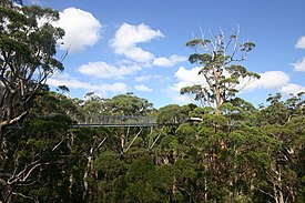
The Valley of the Giants skywalk at Walpole-Nornalup National Park
Western Australia is the second largest country subdivision in the world.
As of 2022, based on the latest Collaborative Australian Protected Areas Database report, it contains 1857 separate land-based protected areas with a total area of 76,142,710 hectares (188,152,700 acres), accounting for just over 30 percent of the state's land mass. By area, Indigenous Protected Areas account for the largest part of this, almost 67 percent while, by number, nature reserves hold the majority with two-third of all land-based protected areas being nature reserves. (Full article...) -

Overview of IUCN Protected area - WAP (W, Arli, Pendjari) area - Niger, Burkina Faso, and Benin
The following is a list of protected areas of Burkina Faso. (Full article...) -
Rock carvings at the Ewaninga Rock Carvings Conservation Reserve
The protected areas of the Northern Territory consists of protected areas managed by the governments of the Northern Territory and Australia and private organisations with a reported total area of 335,527 square kilometres (129,548 sq mi) being 24.8% of the total area of the Northern Territory of Australia. (Full article...) -

Mombacho Volcano Natural Reserve
The protected areas of Nicaragua are areas that have natural beauty or significance and are protected by Nicaragua. Nicaragua has 78 protected areas that cover 22,422 km2, about 17.3% of the nations landmass. The National System of Protected Areas (SINAP) is administered by the Ministry of the Environment and Natural Resources (MARENA). (Full article...) -
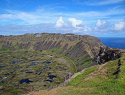
Rano Kau, Parque National Rapa Nui, Easter Island
The protected areas of Chile are areas that have natural beauty or significant historical value protected by the government of Chile. These protected areas cover over 140,000 km2 (54,054 sq mi), which is 19% of the territory of Chile. The National System of Protected Wild Areas (SNASPE by its Spanish acronym) is regulated by law #18,362 passed in 1984, and administered by the National Forest Corporation (CONAF).
There are three types of territories: (Full article...)


Selected world maps
-
 The Goode homolosine projection is a pseudocylindrical, equal-area, composite map projection used for world maps.
 -
 Mollweide projection of the world
 -
 Only a few of the largest large igneous provinces appear (coloured dark purple) on this geological map, which depicts crustal geologic provinces as seen in seismic refraction data
 -
 1516 map of the world by Martin Waldseemüller
 -
 A plate tectonics map with volcano locations indicated with red circles
 -
 United Nations Human Development Index map by country (2016)
 -
 Time zones of the world
 -
 The world map by Gerardus Mercator (1569), the first map in the well-known Mercator projection
 -
 Index map from the International Map of the World (1:1,000,000 scale)


World records
- List of Olympic records in athletics
- List of world records in athletics
- List of junior world records in athletics
- List of world records in masters athletics
- List of world youth bests in athletics
- List of IPC world records in athletics
- List of world records in canoeing
- List of world records in chess
- List of cycling records
- List of world records in track cycling
- List of world records in finswimming
- List of world records in juggling
- List of world records in rowing
- List of world records in speed skating
- List of world records in swimming
- List of IPC world records in swimming
- List of world records in Olympic weightlifting
Topics

Continents of Earth | ||||||||
|---|---|---|---|---|---|---|---|---|
| ||||||||
| ||||||||
| ||||||||


| Cenozoic Era (present–66.0 Ma) |
| ||||||||||||
|---|---|---|---|---|---|---|---|---|---|---|---|---|---|
| Mesozoic Era (66.0–252 Ma) |
| ||||||||||||
| Paleozoic Era (252–539 Ma) |
| ||||||||||||
| Proterozoic Eon (539 Ma–2.5 Ga) |
| ||||||||||||
| Archean Eon (2.5–4 Ga) | |||||||||||||
| Hadean Eon (4–4.6 Ga) | |||||||||||||
ka = kiloannum (thousands years ago); Ma = megaannum (millions years ago); Ga = gigaannum (billions years ago). See also: Geologic time scale • | |||||||||||||
| Locations | ||
|---|---|---|
| Related | ||

| |||||||||||||||||||
| |||||||||||||||||||
| |||||||||||||||||||

Economic classification of countries | |||||
|---|---|---|---|---|---|
| Three-World Model | |||||
| Gross domestic product (GDP) |
| ||||
| Gross national income (GNI) | |||||
| Wages | |||||
| Wealth | |||||
| Other national accounts | |||||
| Human development | |||||
| Digital divide | |||||
| Net international investment position (NIIP) | |||||
| Technological |
| ||||
|---|---|---|---|---|---|
| Sociological | |||||
| Ecological |
| ||||
| Biological |
| ||||
| Astronomical | |||||
| Eschatological |
| ||||
| Others |
| ||||
| Fictional | |||||
| Organizations | |||||
Categories

Wikimedia
The following Wikimedia Foundation sister projects provide more on this subject:
-
 Commons
Free media repository -
 Wikibooks
Free textbooks and manuals -
 Wikidata
Free knowledge base -
 Wikinews
Free-content news -
 Wikiquote
Collection of quotations -
 Wikisource
Free-content library -
 Wikispecies
Directory of species -
 Wikiversity
Free learning tools -
 Wikivoyage
Free travel guide -
 Wiktionary
Dictionary and thesaurus


